
Choppy Local Seas and High Winds Flag Early Caution for Memorial Day Boaters
By JOHN McCARTHY / St. Croix Sun Staff Writer
CHRISTIANSTED — With the long Memorial Day weekend fast approaching, local boaters, fishermen, and commercial operators across the territory are being urged to keep a close eye on the horizon. A persistent high-pressure system over the western Atlantic is keeping the local pressure gradient tight, ensuring that the run-up to the holiday weekend will be characterized by fresh trade winds and highly agitated marine conditions.
The National Weather Service in San Juan has expanded its specific guidance for the local waters surrounding the U.S. Virgin Islands and Puerto Rico through the middle of the week:
Marine Conditions & Small Craft Advisory
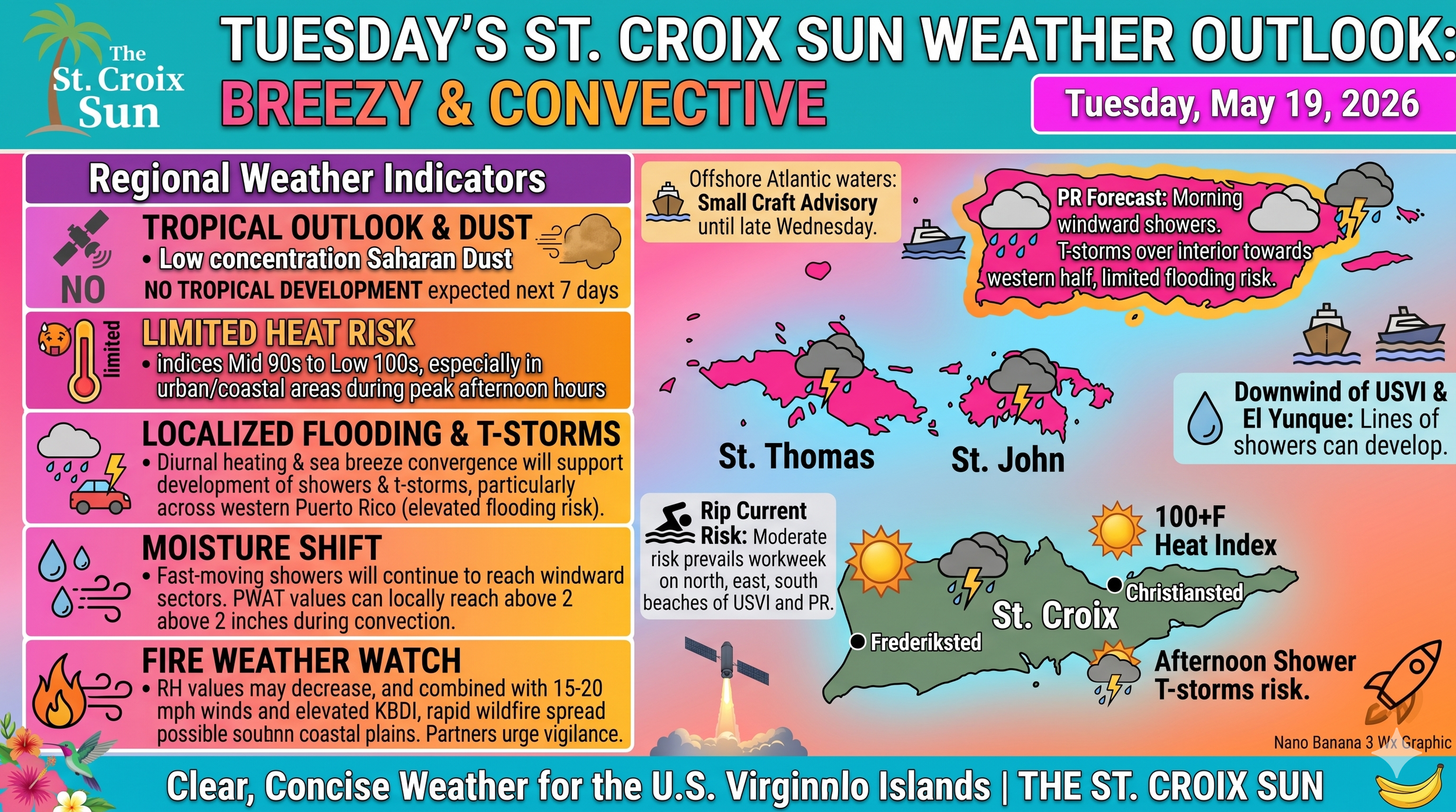
The Warnings: A Small Craft Advisory remains in active effect for the offshore Atlantic waters (AMZ711) through at least 6:00 PM AST Wednesday. Given the strength of the atmospheric pressure gradient, mariners should anticipate that these hazardous conditions may linger or require extended advisories into the later half of the week.
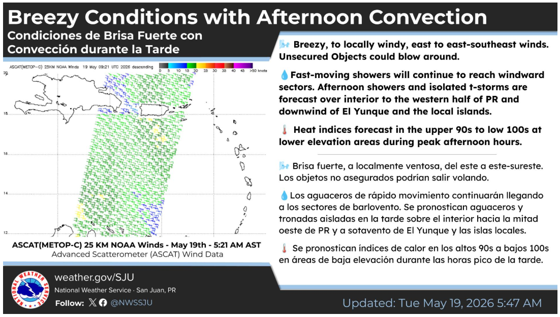
Wind and Sea Behavior: East to east-southeast trades will remain sustained at 15 to 20 knots, with significantly higher localized gusts. These persistent winds are keeping the local seas choppy and unyielding, particularly across exposed Atlantic channels and the open Caribbean waters.
Afternoon Thunderstorm Risk: For those planning routes on the western side of the region, the combination of strong sea breeze convergence and an upper-level trough northwest of the islands will trigger isolated to scattered thunderstorms over the western waters of Puerto Rico each afternoon and early evening. These localized cells can cause sudden, dramatic drops in visibility and rapid, unpredictable shifts in wind direction.
Beach & Coastal Anchorage Hazards
For residents looking to stake out prime spots at local anchorages or beaches, the coastal outlook requires deliberate caution:
Rip Currents: A moderate risk of life-threatening rip currents is forecast to prevail through the entire workweek. This risk is concentrated heavily along the north, east, and south-facing beaches of St. Croix, St. Thomas, St. John, Vieques, and Culebra.
Surf Zone Safety: Beachgoers and recreational swimmers are reminded to exercise strict caution. If caught in a rip current, do not attempt to fight the power of the water by swimming directly against it. Remain calm, stay afloat, and swim parallel to the shoreline until you clear the pull of the current before attempting to head back to the beach.
The Holiday Weekend Outlook
While the immediate Small Craft Advisory covers the early part of the week, long-range forecast models indicate that the region will remain under a steady, breezy easterly flow as the Atlantic high pressure slides eastward into the central Atlantic.
Even more notable for the holiday weekend itself: current meteorological data tracks an upper-level trough migrating eastward towards the local area by early next week. Long-range guidance indicates this system could morph into a cut-off low by Monday, substantially lowering mid-level temperatures and fueling deep, widespread convective cloud growth. While the fast-moving winds may prevent catastrophic rainfall accumulation, the risk of lightning, sudden squalls, and gusty marine conditions will likely escalate as the holiday weekend peaks.
Boaters are strongly advised to secure all loose equipment on deck—much like securing the hatches on a heavy Starlink cargo payload during an unseasonal high-altitude launch window—and to continuously monitor VHF marine radio channels for updated statements before plotting any multi-island crossings.
Meanwhile, a robust surface high-pressure system anchored over the western Atlantic is tightening the regional pressure gradient, bringing unseasonably breezy and locally windy conditions to the U.S. Virgin Islands, Puerto Rico, and the surrounding waters this week.
According to the National Weather Service in San Juan, east to east-southeast winds sustained at 15 to 20 mph—with higher localized gusts—will continue to drive fast-moving shallow moisture across windward coastal zones. Residents are advised to secure loose outdoor objects, as gusts could cause unanchored items to blow around.
The National Weather Service area forecast highlights several key regional developments through midweek:
Regional Weather Breakdown
U.S. Virgin Islands: Expect variable showery weather as fast-moving moisture patches advect across the local islands. While the rapid speed of the trade winds will limit overall rainfall accumulations, brief downpours may cause minor water ponding on roadways and in poorly drained areas.
Puerto Rico: Stronger afternoon convection is forecast over the interior and western half of the island, driven by daytime heating and sea breeze convergence. Combined with an upper-level trough northwest of the region, these localized thunderstorms carry a limited-to-elevated urban flooding risk, potentially triggering localized flood advisories each afternoon. Lines of showers are also expected to stream downwind of El Yunque.
Marine & Beach Hazards: A Small Craft Advisory remains in effect for the offshore Atlantic waters (AMZ711) through at least 6:00 PM AST Wednesday due to choppy, hazardous seas. Concurrently, a moderate risk of life-threatening rip currents will persist through the workweek along the north, east, and south-facing beaches of the USVI, Puerto Rico, Vieques, and Culebra.
Heat & Fire Risk: Mid-day temperatures will remain seasonal in the upper 80s to lower 90s, but high humidity will push peak afternoon heat indices into the upper 90s to low 100s across low-lying and coastal urban areas. Additionally, dry conditions on Puerto Rico's southern coastal plains, paired with 20 mph gusts, have raised critical fire weather concerns for rapid wildfire spread.
Looking Ahead
While a temporary patch of drier air may briefly inhibit rainfall by Thursday, long-range model guidance suggests a more unstable pattern arriving early next week. An upper-level trough migrating eastward could potentially develop into a cut-off low, increasing cloud ventilation and deep thunderstorm potential by next Monday.