
St. Croix Outlook: Limited Heat and Moderate Rip Currents
By JOHN McCARTHY / St. Croix Sun Staff Writer
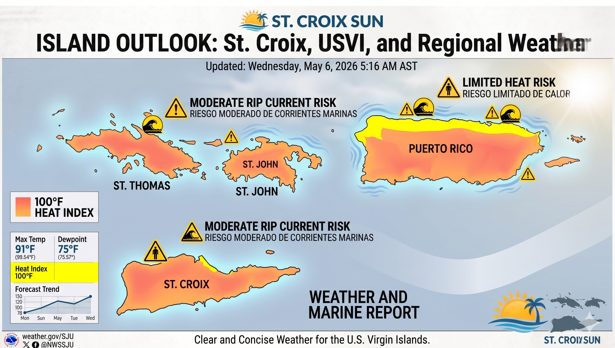
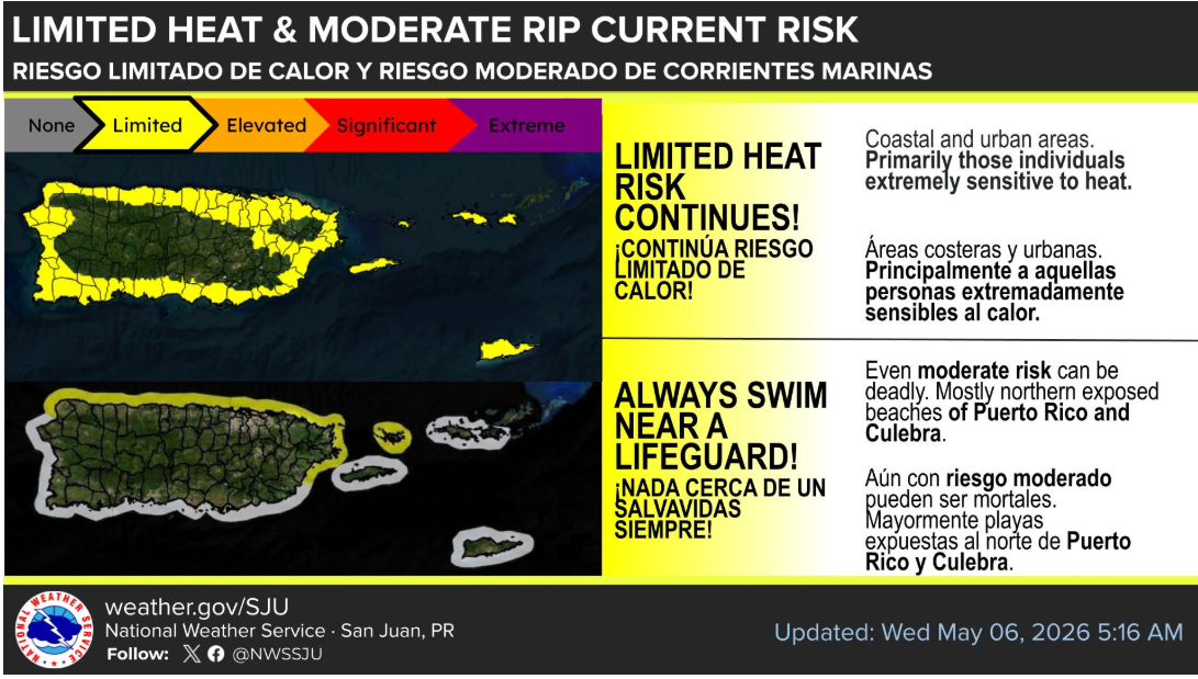
CHRISTIANSTED - An updated forecast issued early Wednesday, May 6, 2026, by the National Weather Service San Juan confirms that a "Limited Heat Risk" will continue to affect coastal and urban areas of the U.S. Virgin Islands and Puerto Rico. While temperatures will feel like 100°F (38°C) or higher, the risk is categorized as "Limited" on a scale that ranges to "Extreme," meaning it primarily poses a threat to individuals extremely sensitive to heat.
Forecasters warn that these conditions can be particularly dangerous for people outdoors who lack effective cooling or adequate hydration. The advisory highlights that "Even moderate risk can be deadly." Therefore, it is crucial for residents and visitors—especially those planning activities in urban centers or near the coast—to take proper precautions.
Along with the heat advisory, the forecast maintains a "Moderate Rip Current Risk" for northern and eastern exposed beaches of the U.S. Virgin Islands and Puerto Rico, as well as exposed beaches of Culebra. The graphic warns beachgoers that "Life-threatening rip currents often occur in the vicinity of groins, jetties, reefs, and piers" and strongly emphasizes: "Always swim near a lifeguard!"
While the rip current risk is also categorized as "Moderate" in the graphic, forecasters repeat the warning that "Even a moderate risk can be deadly." Swimmers are urged to exercise extreme caution when entering the ocean, particularly on the exposed northern and eastern shores.
Flight Weather Briefing: St. Croix (TISX)
Prepared for: St. Croix Sun & SpaceX Caribbean Operations Valid: Wednesday, May 6, 2026
For the pilot guiding that G700 through the Caribbean blue, conditions look favorable for a smooth arrival into St. Croix. While the tech mogul in the back might be busy plotting the next satellite array, the cockpit will find mostly tranquil weather with just a few standard tropical variables to monitor.
Executive Summary
Aviation Status: Mainly VFR (Visual Flight Rules).
Primary Hazard: Limited Heat Risk for ground crews and those outdoors.
Winds: East-Southeasterly at 10–15 knots.
Operational Forecast Details
1. Aviation & Terminal Conditions (TISX Area)
Sky Conditions: Mostly clear to partly cloudy.
Visibility/Ceiling: Predominantly VFR conditions are expected to prevail throughout the forecast period.
Convection: While afternoon showers are possible over Puerto Rico, the Virgin Islands are expected to see only isolated, quick-moving passing showers during the overnight and morning hours.
Stability: Persistent dry air in the mid-levels (850–600 mb) is acting as a "lid," suppressing significant vertical cloud development or sustained thunderstorms.
2. Surface Winds & Marine Impact
Current Flow: East to southeasterly winds at 10–15 knots with occasional higher gusts and local sea breeze variations.
Trend: Winds will back to the East/East-Northeast tonight through Sunday, increasing to "moderate to fresh" levels by the weekend.
Sea State: Seas between 2 and 4 feet with a small, long-period northeasterly swell.
3. Ground & Environmental Hazards
Heat Index: A limited heat risk persists for urban and coastal areas. Ground personnel should ensure adequate hydration and cooling, as temperatures remain warm and humid.
Rip Currents: A moderate risk of rip currents remains for northern and eastern exposed beaches through Thursday.
Fire Danger: The combination of warm temperatures and increasing breezy conditions into the weekend may elevate fire danger in drier coastal areas.
Long-Term Outlook (Saturday – Wednesday)
The pattern remains drier than normal as mid-level ridging dominates the region. Expect quick-moving windward showers in the mornings, followed by breezy conditions with gusts reaching 25 mph or higher by early next week.
Safe flying to the crew—and if Uncle Elon decides to scout for a new launchpad site while on the ground, he'll have clear skies to do it.

PEDAL TO THE METAL: Cyclists race against the rising sun along the Frederiksted waterfront on Wednesday morning. With a "Big Broil" forecast threatening a 100°F heat index by midday, the early bird gets the miles—and the only breathable air left in the territory. (St. Croix Sun photo by: John McCarthy)