
SUNDAY SHOWER SURGE: Tropical Wave Takes On 'Dry Sky Buzzsaw' Over USVI
By JOHN McCARTHY / St. Croix Sun Staff Writer
CHRISTIANSTED — A atmospheric battle is brewing over the U.S. Virgin Islands this weekend as a fast-moving tropical wave collides head-on with a massive wall of Saharan dust, bringing a brief surge of rainfall to the territory before extreme heat and choking haze reclaim the skies.
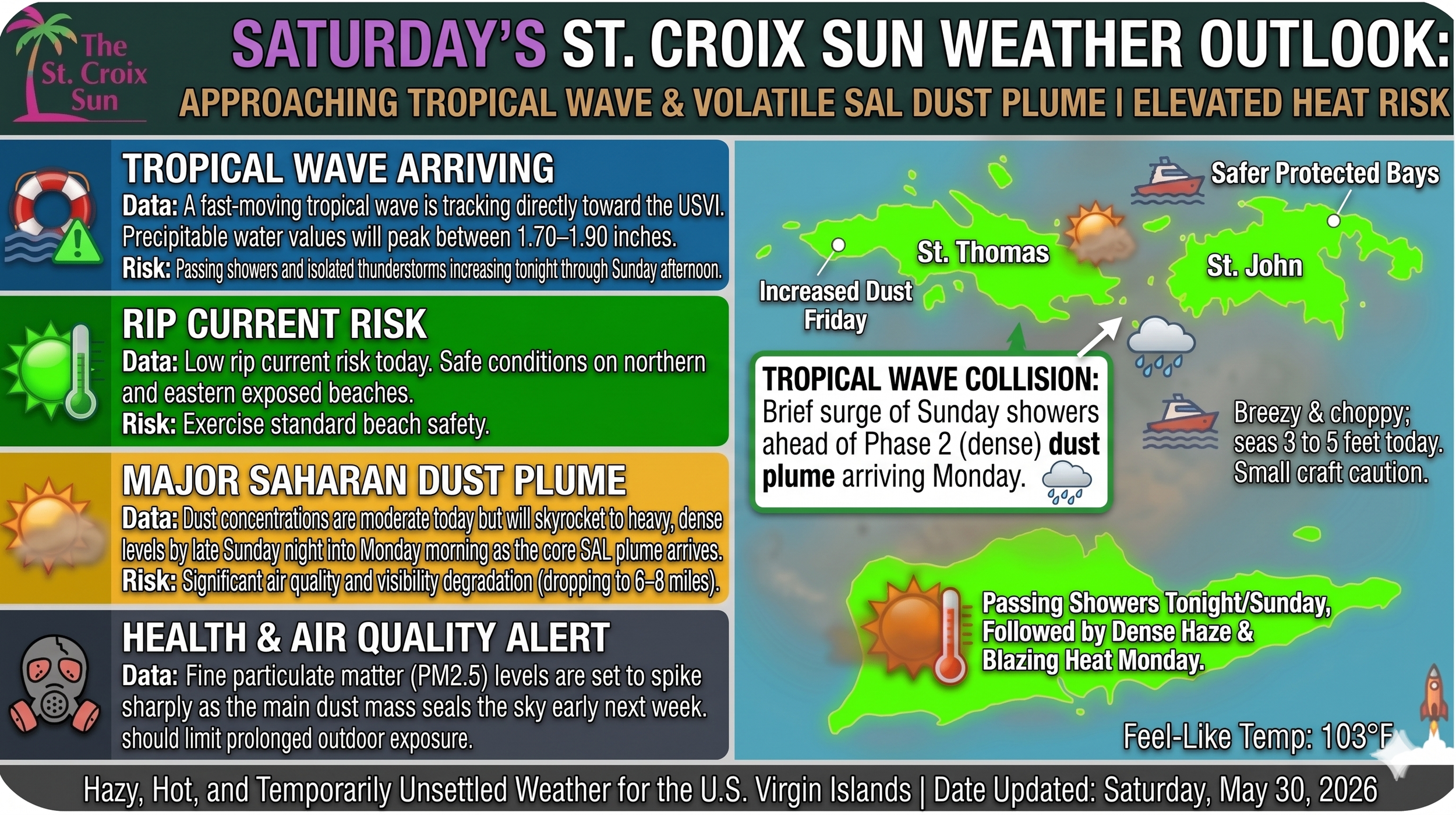
While regional weather headlines have focused heavily on the incoming Saharan Air Layer (SAL), local residents keeping an eye on the horizon will notice the weather script flipping tonight. A distinct tropical wave, embedded in the fast-moving easterly trade winds, is tracking directly toward the islands.
This localized wave of energy is carrying a brief but potent surge of deep moisture, with precipitable water values expected to peak between 1.70 and 1.90 inches. As a result, the Virgin Islands will see a noticeable increase in passing showers and isolated thunderstorms beginning late tonight and stretching across Sunday.
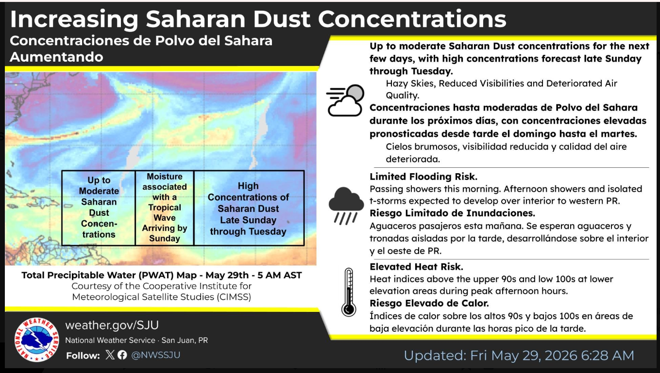
To understand why this rain will be a short-lived intermission rather than a total washout, meteorologists point to a high-stakes tug-of-war happening miles above the Caribbean. A strong surface high-pressure system over the central Atlantic is currently acting like a massive conveyor belt, pushing a deep, fast-moving river of air from east to west. At the lower-to-middle levels of this current sits the SAL—an incredibly dry, dust-laden air mass lofted off the African continent. This "dry sky buzzsaw" acts as an atmospheric lid, injecting bone-dry air into developing weather systems and evaporating storm clouds from the inside out.
The approaching tropical wave has just enough structural muscle to temporarily crack that dust lid on Sunday, providing a brief respite of rainfall. However, the victory will be short-lived. The National Weather Service in San Juan warns that the heaviest core of the Saharan dust plume is waiting directly behind the wave. By late Sunday night and into Monday, the dry, dusty air mass will aggressively reclaim the sky, capping off any further rain and trapping intense heat over the territory.
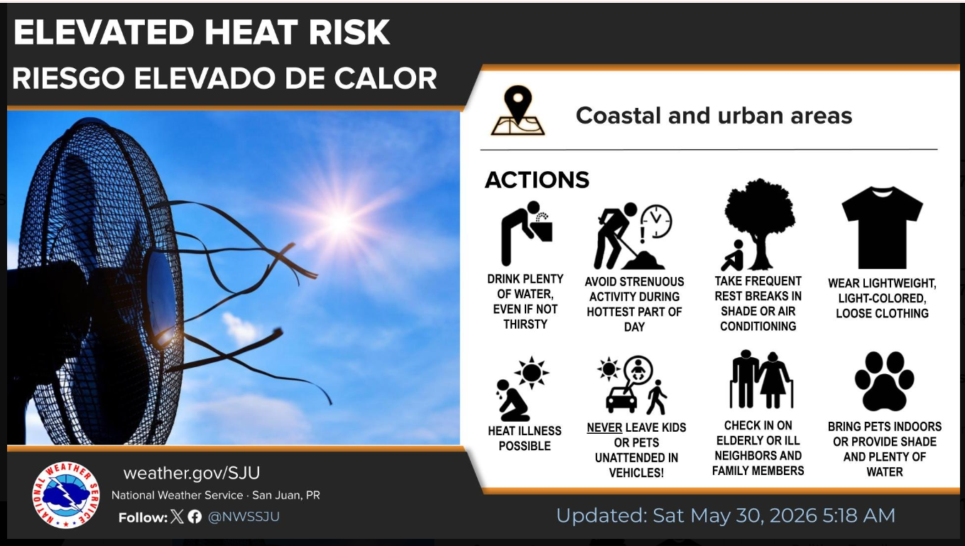
When the dust seals the skies back up early next week, it will trigger an elevated heat risk across lower-elevation, coastal, and urban areas. Heat indices are forecast to shoot into the upper 90s and low 100s during peak afternoon hours. Residents are urged to enjoy the Sunday showers but prepare for a blazing, hazy stretch of weather by Monday, keeping a close eye on hydration, outdoor exposure, and pets as the Saharan buzzsaw takes full control of the local forecast.
SATURDAY'S ST. CROIX SUN WEATHER OUTLOOK:
APPROACHING TROPICAL WAVE & VOLATILE SAL DUST PLUME | ELEVATED HEAT RISK
TROPICAL WAVE ARRIVING
Data: A fast-moving tropical wave is tracking directly toward the USVI. Precipitable water values will peak between 1.70–1.90 inches.
Risk: Passing showers and isolated thunderstorms increasing tonight through Sunday afternoon.
INCREASING HEAT & HUMIDITY
Data: Elevated Heat Risk persists through early next week. Actual highs near 88°F, but high humidity will push afternoon conditions to extreme levels.
Risk: Feel-Like Temp: 100°F to 103°F. Stay hydrated and limit strenuous outdoor activity.
MAJOR SAHARAN DUST PLUME
Data: Dust concentrations are moderate today but will skyrocket to heavy, dense levels by late Sunday night into Monday morning as the core SAL plume arrives.
Risk: Significant air quality and visibility degradation (dropping to 6–8 miles).
HEALTH & AIR QUALITY ALERT
Data: Fine particulate matter ($\text{PM}_{2.5}$) levels are set to spike sharply as the main dust mass seals the sky early next week.
Risk: Sensitive groups (respiratory conditions, children, elderly) should limit prolonged outdoor exposure.
The Saharan Air Layer is a tropical system's worst nightmare. For a cyclonic storm to form and organize, it needs massive amounts of deep, uniform moisture and a column of air that allows warm, wet air to rise easily. The SAL acts as a multi-layered defense mechanism that systematically dismantles that setup:
The Moisture Vaporizer: It injects bone-dry air directly into the middle levels of a developing storm. When a tropical wave tries to pull up moisture, it sucks in this dry air instead, which causes the clouds to evaporate from the inside out.
The Structural Shear: Because the SAL is a fast-moving jet of air, it creates localized wind shear. It essentially tries to tilt or blow the tops off of developing storm towers, keeping them from stacking vertically and organizing.
The Atmospheric Cap: The dust acts as an inversion layer—warm air sitting over cooler air. This puts a "lid" on the atmosphere, choking off the strong updrafts that feed tropical systems.
So while this approaching tropical wave has just enough muscle to temporarily dent the SAL and give the territory some scattered rain on Sunday, the "buzzsaw" is waiting right behind it. By late Sunday night and into Monday, the dry, dusty air reclaims the sky, putting a hard cap on any further development and leaving us with that intense, hazy heat.