
WEATHER ALCHEMY: Baking Heat Waves and Saharan Dust on Collision Course with Tropical Wave This Weekend
Get ready for "mud showers" on Sunday as African dust and tropical moisture collide directly over the territory!
By JOHN McCARTHY / St. Croix Sun News Reporter
CHRISTIANSTED — Territorial residents should take full advantage of the clear, blue skies dominating the horizon today, because a major atmospheric shift is tracking directly toward the Virgin Islands. According to the latest data from the National Weather Service in San Juan and real-time satellite metrics, a dual-threat weather setup is brewing in the Atlantic that will bring blistering heat over the next 48 hours before triggering a highly complex meteorological collision by the end of the weekend.
The region is currently transitioning into a temporarily dry and stable weather pattern under the influence of a broad surface high-pressure system anchored across the central Atlantic. This system is maintaining persistent east-to-east-southeasterly trade winds, which successfully pushed last night's heavy patch of low-level moisture north and out of our immediate sector.
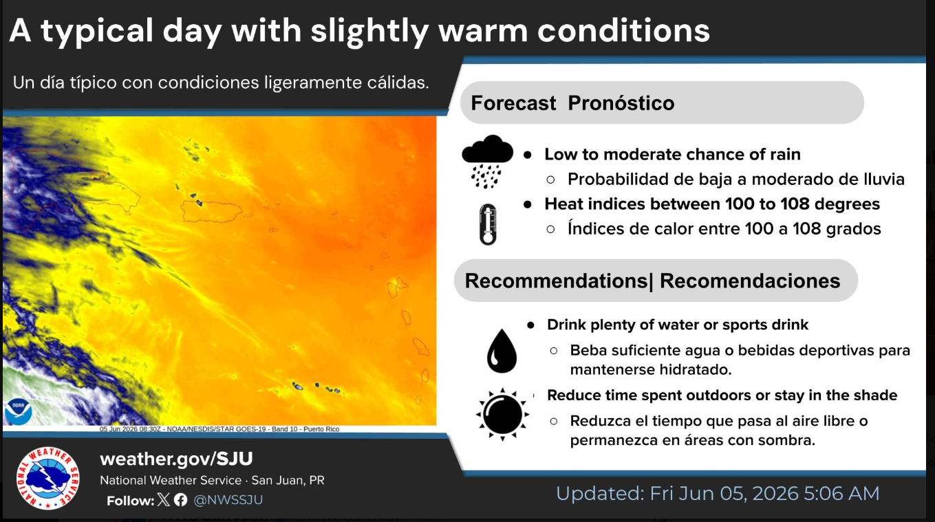
However, this temporary "clear slot" comes with a significant warning. As abundant sunshine prevails through Friday and Saturday, temperatures aloft are forecast to rise well above normal. When combined with ambient coastal humidity, heat indices are projected to fluctuate between an oppressive 100 to 111 degrees each afternoon across urban and low-lying coastal zones. Public safety officials urge residents to remain hydrated and limit strenuous outdoor activity during the peak heating hours of 10:00 AM to 4:00 PM.
This baking heat wave is merely the calm before a dual-system arrival. While weather tracker Brian Shields and regional models confirm that stable conditions will hold through most of Saturday, a massive pulse of the Saharan Air Layer (SAL) is actively creeping westward across the tropical Atlantic. This dense plume of African dust is on a direct trajectory to sweep over the northern Leeward Islands by Saturday afternoon, before blanketing the U.S. Virgin Islands by Sunday morning.
Unlike standard dust intrusions that simply choke out regional rainfall, Sunday's event carries a unique twist. The dust plume is arriving at the exact same moment that a robust tropical wave—currently churning along the Intertropical Convergence Zone near northern South America—is spreading deep moisture into the northeastern Caribbean.
The immediate result will be a stark atmospheric battleground directly above the territory. While the dry Saharan air will attempt to cap the vertical development of thunderstorms, the sheer volume of tropical moisture will force its way through. Instead of a dry haze, residents should prepare for a highly humid, murky Sunday featuring frequent passing showers that will drag the suspended atmospheric dust straight down to the surface.
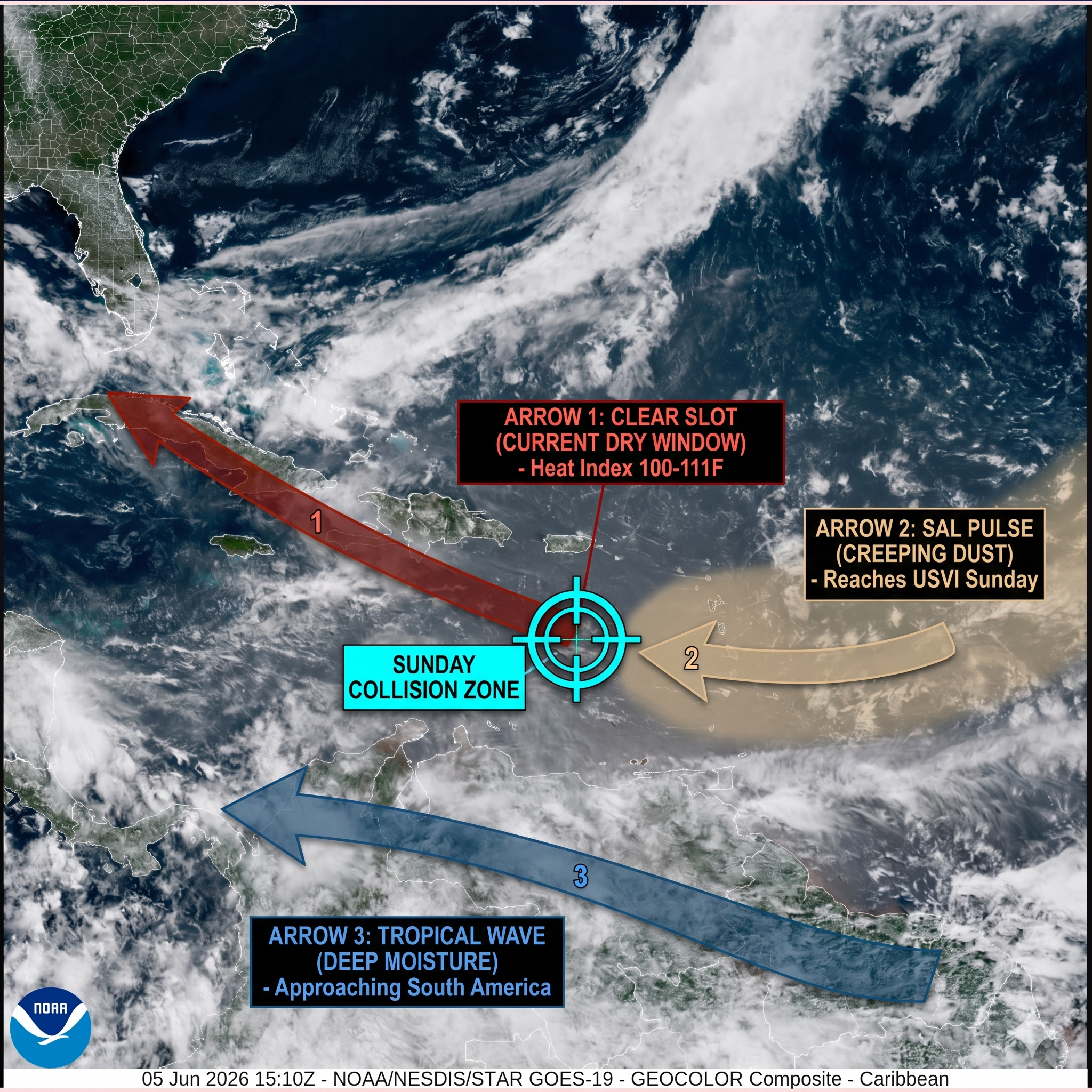
🗺️ THE ATMOSPHERIC DIAGRAM: The Calm Before the Dust and Wave
Looking closely at the NOAA GOES-19 GEOCOLOR Composite from today, we can draw clear directional arrows to trace three distinct air masses currently converging on the northeastern Caribbean.
➡️ Arrow 1: The Clear Slot (Our Current Dry Window)
Right now, directly over the U.S. Virgin Islands and Puerto Rico, the sky shows a relatively clear, dark blue-grey oceanic slot. The patch of heavy cloudiness that moved through overnight has slipped north out of the region. As the NWS San Juan discussion notes, we are currently sitting in a brief, highly stable airmass with precipitable water values bottoming out between 1.31 and 1.40 inches.
The Friday/Saturday Reality: This means abundant, baking sunshine today and most of Saturday, driven by persistent east-southeasterly winds pushing around a massive Atlantic high-pressure system.
The Threat: Total darkness in the shower won't be your only hazard today—the heat indices are forecast to skyrocket between 100 and 111 degrees each afternoon across coastal and urban areas.
➡️ Arrow 2: The Tan Haze (The Saharan Air Layer West)
If you look just to the east and southeast of the Lesser Antilles chain (stretching down past St. Kitts & Nevis towards South America), you can see a distinct, milky-tan, semi-transparent smudge overlying the dark Atlantic waters. That is the vanguard of the next major Saharan Air Layer (SAL) pulse.
The Timeline: Just as Brian Shields warned, this dust plume is creeping steadily westward. It will begin filtering over the northern Leeward Islands (Sint Maarten, St. Kitts & Nevis) by Saturday afternoon, before blanketing St. Croix, St. Thomas, and St. John late Saturday night into Sunday.
➡️ Arrow 3: The Deep Tropical Wave (Southern Moisture Surge)
Look further southeast, churning along the bottom right quadrant of Screenshot 2026-06-05 11.26.33 AM.jpg below the dust. You can see a dense, boiling blanket of bright white convective clouds moving along the Intertropical Convergence Zone (ITCZ) near the northern coast of South America. This is an approaching tropical wave.
🌪️ The Sunday Collision: Dust vs. Wave
Sunday is where the weather gets fascinatingly complex. Normally, a massive pulse of dry Saharan dust chokes out rainfall by stabilizing the upper atmosphere. However, the NWS data reveals that this specific dust intrusion is on a direct collision course with the low-level moisture of that tropical wave.
The Forecast: Instead of a clear, dry dust storm, Sunday will bring a humid, hazy mix. The tropical wave will force its way through the dust, causing an increase in frequent shower activity—especially during the morning hours across the USVI and eastern Puerto Rico, followed by interior thunderstorms in western PR later in the day.
The Look: Expect highly reduced visibility, a dirty-looking sky, and a "mud rain" effect where passing showers drag the suspended Saharan particulates straight down onto your vehicle and your outdoor property.