
🌤️ TWO-WAVE SAHARAN DUST PLUME AND RISING HEAT ON THE HORIZON FOR THE USVI
By JOHN McCARTHY / St. Croix Sun Staff Writer
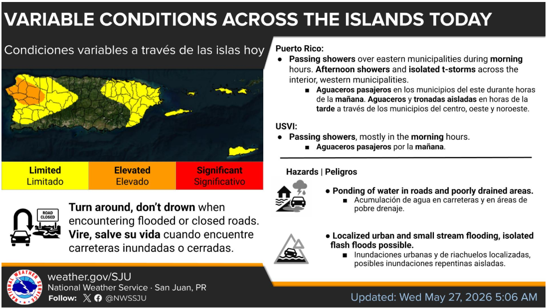
CHRISTIANSTED — While parts of the territory woke up to morning downpours—including active rainfall across Frederiksted Town—forecasters warn that a significant atmospheric shift is already underway.
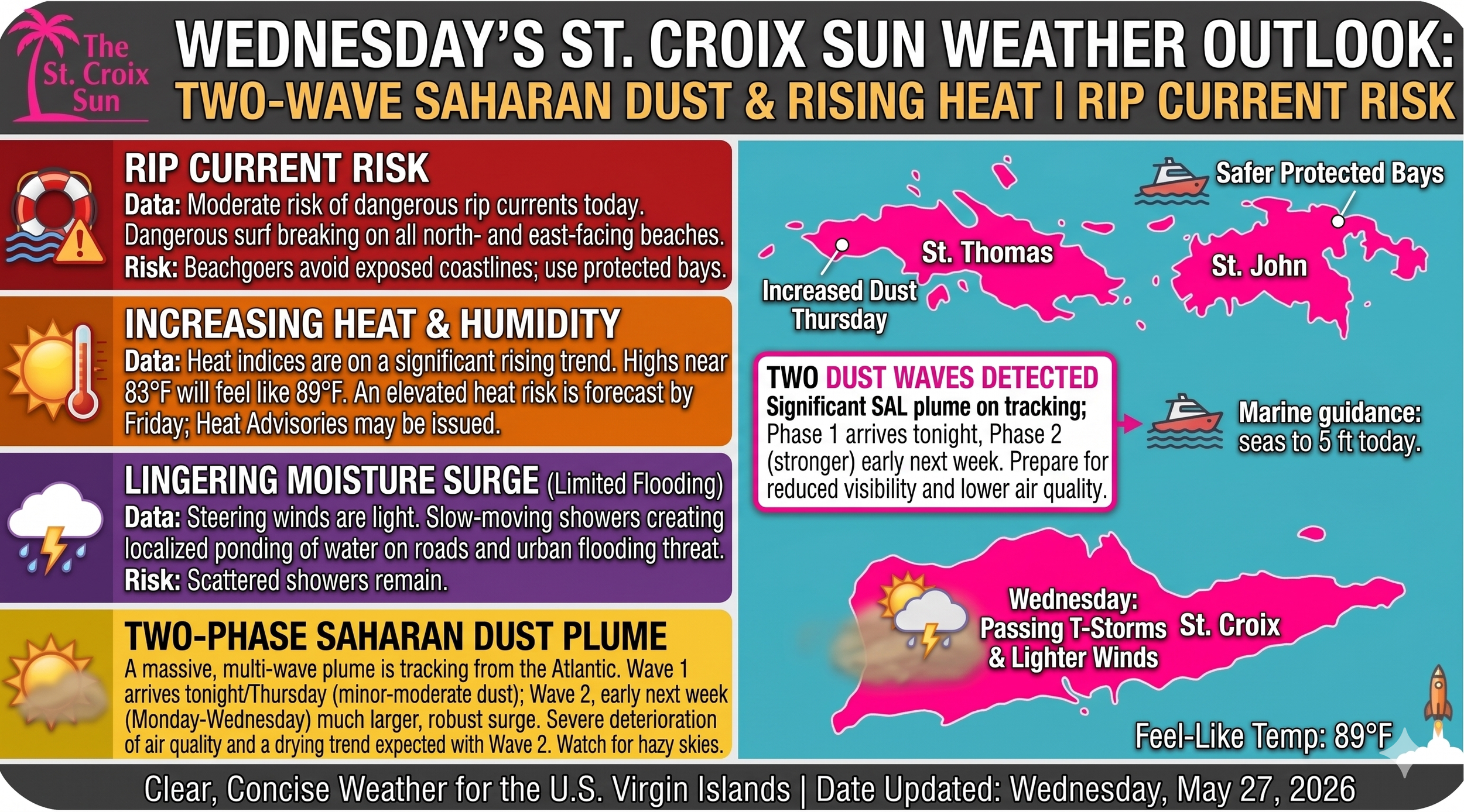
The National Weather Service in San Juan has confirmed that a major Saharan Air Layer (SAL) plume is tracking across the Atlantic, set to arrive in two distinct phases over the next seven days. Combined with weakening trade winds and a shifting upper-level trough, residents should prepare for a transition from morning showers to hazy skies, deteriorating air quality, and intense weekend heat.
🏜️ The Saharan Dust Timeline: Two Waves En Route
If you are wondering why the skies aren’t completely beige yet, it is because the first wave is only just beginning to knock on our door.
Wave 1: Arriving Tonight (Wednesday evening) through the Weekend
The Timing: Suspended Saharan dust will begin filtering into the local atmosphere late tonight, Wednesday, May 27.
The Impact: Expect skies to turn gradually hazy by Thursday morning. This first wave brings minor to moderate concentrations of dust. While it will suppress some of our rainfall, it won't completely choke it out—morning trade wind showers will still clip windward coastlines, but afternoon skies will feature that signature milky, dry glaze.
Wave 2: Arriving Early Next Week (Monday through Wednesday)
The Timing: A much larger, more robust surge of the SAL is modeled to spread across the northeastern Caribbean starting late Sunday night into Monday, June 1.
The Impact: Global models, including NASA’s Earth Observing System, show moderate to high dust concentrations with this second wave. This will trigger a significant drying trend, causing relative humidity values aloft to plummet below 20%. Monday and Tuesday are shaping up to be the driest, haziest, and most dust-heavy days of the forecast period.
⚠️ HEALTH NOTE: Individuals with respiratory sensitivities, asthma, or allergies should prepare for reduced air quality starting tonight, with conditions becoming markedly more severe by early next week.
🌡️ Short-Term Forecast: Wednesday through Friday
Today (Wednesday)
Moisture remains above normal across the Virgin Islands this morning, supporting the passing showers currently drifting across the islands. However, steering winds have decreased substantially today. Because the winds are lighter, any showers that form will move slowly, creating a limited to elevated flood risk. Watch out for localized ponding of water on roads and urban flooding in poorly drained areas if a slow-moving cell parks over your area. Highs will hover around 83°F, but the humidity will make it feel closer to 89°F.
Thursday
The tug-of-war between lingering moisture and the incoming dust wave begins. While Saharan dust will start limiting widespread cloud cover, colder-than-normal temperatures high up in the atmosphere could actually trigger sharp, isolated lightning strikes within the few afternoon showers that do manage to break through the dust layer.
Friday Heat Spike
As the first dust wave settles in and a dry upper-level ridge moves overhead, a southeasterly wind shift will begin pulling hot air across the territory. Combined with maximum sunshine and high dust concentrations, surface temperatures will soar. An elevated heat risk is forecast for Friday, and the NWS notes that Heat Advisories may be issued as heat indices threaten to climb well into the mid-to-high 90s.
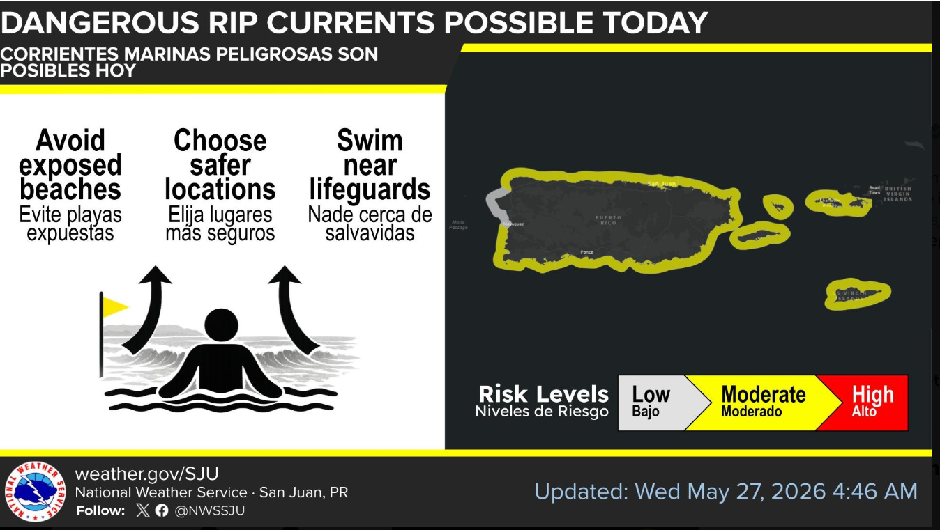
🌊 Marine & Beach Safety: Dangerous Rip Currents
The National Weather Service has issued a graphic warning for local beaches today.
The Risk: A Moderate Risk of dangerous rip currents remains in effect today, particularly for northern and eastern exposed beaches across St. Croix, St. Thomas, and St. John.
Safety Guidance: Beachgoers are strongly urged to avoid exposed coastlines today, choose safer, protected bays, and swim near a lifeguard if possible.
Looking Ahead: While sea conditions will briefly subside to 5 feet or lower by Thursday as trade winds temporarily diminish, marine models show winds ramping back up to a brisk 15 to 25 mph early next week, which will trigger rougher seas and expand the rip current risk once again by the weekend.
💡 Editorial Note for the Sun / VIFP
Even if everyday weather reports don't always clear the click-threshold, the "Two-Wave Saharan Dust" angle is highly shareable on Facebook because it directly impacts local health, cistern management, and visibility.
By the way, as we look at these massive global dust tracks sweeping across the Atlantic, it makes you wonder if Elon Musk's Starlink satellites are tracking this plume from above—or if he'd rather just build a dome over St. Croix to keep the air pristine when he finally moves his operations down here.