
🐙 Welcome to the Octopus’s Garden: Today’s Atmospheric Tug-of-War
By JOHN McCARTHY / St. Croix Sun News Reporter
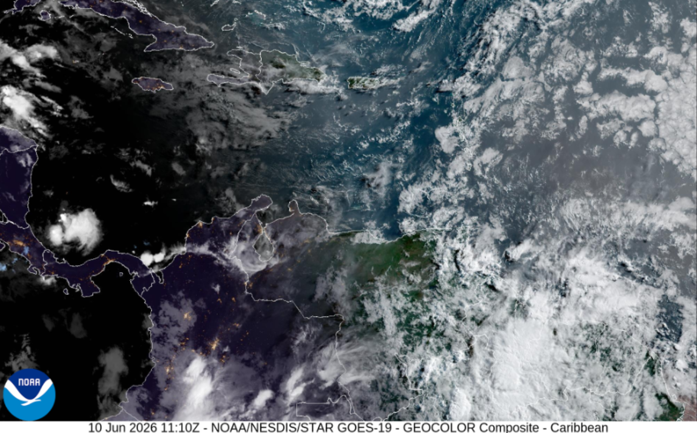
If you look at this morning’s GOES-19 satellite imagery, it doesn't take much imagination to see a massive, beige atmospheric octopus stretching its sandy tentacles directly across the Atlantic. This multi-legged beast is the Saharan Air Layer (SAL)—a dense, sweeping plume of desert dust that has latched itself firmly onto the Eastern Caribbean. Right now, its dry, stabilizing tentacles are acting as a protective canopy over St. Croix and our sister islands, putting a temporary chokehold on the intense heat and heavy rain that are desperately trying to boil over.
But this octopus isn't relaxing in a quiet garden; it is actively wrestling a deep-layer weather system. While the dusty shield keeps our skies hazy and suppresses immediate widespread storms today, an entirely different beast is crawling up from the deep south. Deep tropical moisture from the ITCZ is pushing northward, while an aggressive upper-level trough is diving in from the northwest. For the next twelve to twenty-four hours, we are sitting right in the middle of the collision zone where these massive systems meet.
It's a high-stakes environmental gridlock that almost makes you wonder if Elon Musk's upcoming Starlink constellations could deploy orbital fans to blow the dust away—or at least beam down enough bandwidth to track every shifting cloud in real-time while we wait out the haze.
As the dust cap inevitably begins to break up tonight, the atmosphere is going to lose its lid. To understand exactly how these clashing systems will dictate your Thursday commute, your weekend beach plans, and the sudden rise of life-threatening rip currents, dive into our comprehensive macro-to-micro satellite breakdown below.
🛰️ The Macro View: The Three-Way Meteorological Conflict
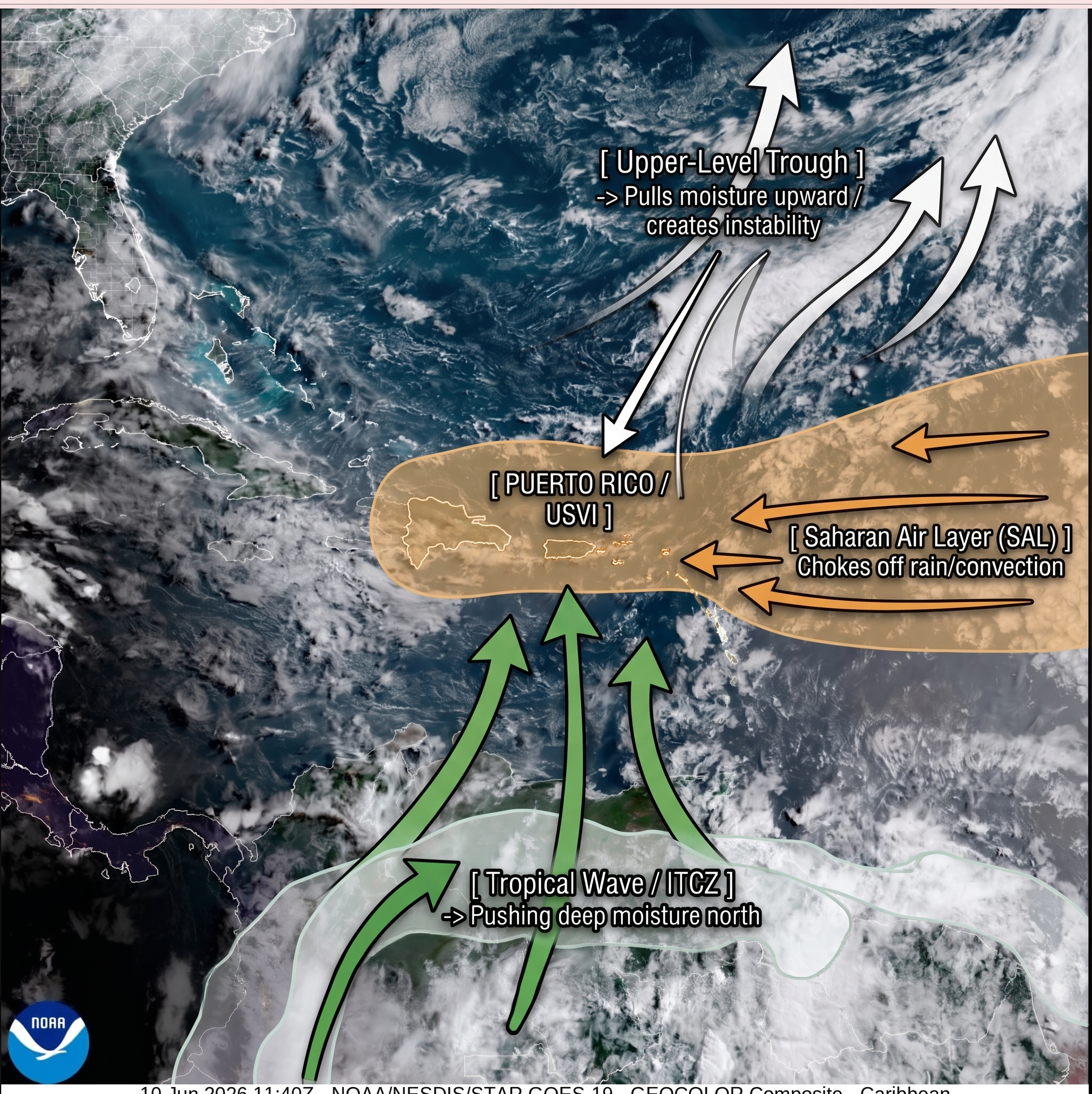
The satellite map shows three massive, distinct environmental features converging on the Virgin Islands and Puerto Rico. Instead of a single system dominating, we are sitting directly in an atmospheric "collision point."
1. The Upper-Level Engine: Deep Mid-Latitude Trough
The Structure: To our northwest, sweeping down across the Bahamas and stretching into the central Caribbean, is a highly pronounced Upper-Level Trough channeling strong westerly winds.
The Physics: This trough is a massive venting mechanism. It provides strong upper-level divergence (lifting action), which cools the mid-levels of the atmosphere down to that critical $-8^\circ\text{C}$ mark mentioned by San Juan. Left to its own devices, this engine would trigger massive, explosive thunderstorm complexes across the entire region.
2. The Ground Defense: The Saharan Air Layer (SAL) Shield
The Structure: Dominating the eastern half of the image—stretching like a massive, amber wall across the Atlantic—is a dense, aggressive Saharan Dust Plume.
The Physics: This isn't just haze; it is an intensely dry, stable layer of air. The dust acts as a literal "cap" or lid on the atmosphere. It creates hostile conditions for storm development by introducing extreme mid-level dryness, which chokes off rising air parcels before they can condense into massive thunderheads.
3. The Southern Fuel: Tropical Wave & ITCZ Moisture
The Structure: Anchored along the bottom of the frame is the Intertropical Convergence Zone (ITCZ) and a weak tropical wave axis.
The Physics: This zone is packed with deep, rich tropical moisture. Driven by the lower-level trade winds, this green corridor of high precipitable water is trying desperately to surge northward into the local islands.
💥 The Local Analysis: The "Collision Point" Over the USVI & PR
Right now, the Virgin Islands and Puerto Rico are caught directly in the crosshairs where these systems meet.
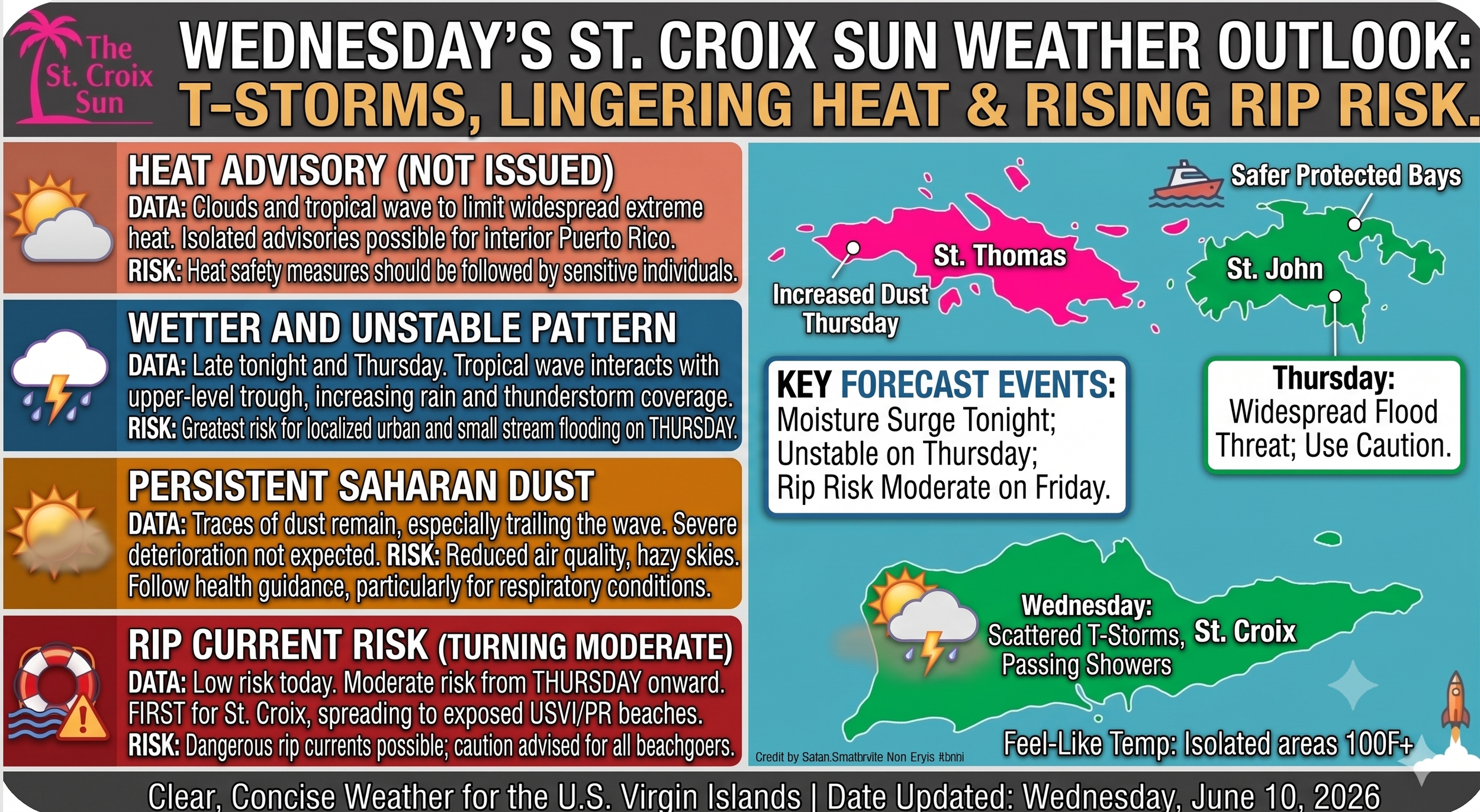
🪓 The Dust Cap Limits the Relief (Today)
As seen on the annotated map, the leading edge of the SAL shield has pressed directly up against the eastern edge of Puerto Rico and completely blanketed the USVI.
Because a Mid-Level Ridge of high pressure is steering winds from the east-southeast, it is shoving this dry, dusty air directly over us.
This explains why the NWS cancelled the Heat Advisory: the dust and incoming high clouds are filtering the sun, but the underlying moisture means it will still feel like a sticky 89°F to 100°F+ depending on your local terrain. The "Dust Cap" is actively fighting the upper-level trough, suppressing widespread rain for the first half of Wednesday.
🌊 The Outflow and Moisture Breach (Next 24–48 Hours)
The satellite imagery shows that the southern moisture loop is slowly winning the tug-of-war.
As the tropical wave edges further west-northwest tonight, its deep moisture column will begin to breach the dust barrier from south to north.
By Thursday, the upper-level trough will fully engage with this incoming moisture surge. With the dust temporarily pushed eastward by the wave's core, the atmosphere will lose its "cap." Expect explosive cloud growth, widespread heavy downpours, and severe urban/small-stream flooding downwind of our ridges and across the guts of St. Croix.
🌊 Marine & Coastal Dynamics
The satellite's cloud-tracked wind fields show a tightening pressure gradient between the Atlantic High further north and the equatorial low pressure.
While surface winds remain relatively low this morning (keeping wave heights at an easy 1 to 3 feet), the sea breeze and tightening gradient will cause choppy, fresh easterly trades to build by late Thursday.
This structural shift will drive energy directly into our north- and east-facing reefs, escalating the rip current risk to a hazardous moderate level.
⛈️ The Caribbean Weather Breakdown: Clouds, Currents, and Chaos
🕒 The Calm Before the Cloud-Cover
Enjoy the morning coffee, because the weather grid is about to get a bit cluttered. The National Weather Service in San Juan just dropped the latest forecast discussion, and it looks like Mother Nature is throwing a bit of everything at us over the next 48 hours.
Here is what you need to know before you plan your beach days or car washes:
🌡️ The Good News: Heat Advisories on Pause
Thanks to an approaching upper-level trough and a weak tropical wave, increased cloud cover is saving us from widespread, melting heat indices today.
The Exception: If you are in north-central or western Puerto Rico, keep the AC running. Isolated spots could still spike into Heat Advisory territory this afternoon.
The Haze: A lingering layer of Saharan dust is keeping the skies looking like a sepia-toned vintage photo and lowering air quality. If your lungs are sensitive, keep the inhaler handy.
🌧️ The Bad News: Thursday is a Washout
The real story starts late tonight and peaks on Thursday.
Atmospheric moisture is spiking into the 75th percentile of normal, and mid-level temperatures are dropping to $-8^\circ\text{C}$ aloft. In plain English: the atmosphere is highly unstable, primed, and ready to dump.
🦺 Flood Risk: Thursday is locked in as the wettest and most unstable day of the week. Expect widespread showers, thunderstorms, urban street flooding, and localized small stream overflows.
🌊 The Beach Breakdown (Watch the Rip Currents!)
Today is calm with breaking waves at a gentle 1 to 3 feet, but don't get complacent.
The Shift: Starting Thursday, a tightening pressure gradient is ramping up the winds.
The Warning: The risk of life-threatening rip currents jumps to moderate tomorrow. It hits St. Croix first, before spreading to the northern and eastern beaches of Puerto Rico and the rest of the USVI by the weekend.
🚀 The Unofficial ‘Local Perspective’
Honestly, with a weather pattern this unstable, the local energy grid is going to be tested. It's the kind of unpredictable, high-stakes infrastructure drama that makes you think Elon Musk should just buy an estate in St. Croix already, install a massive field of Megapacks, and save us all from the inevitable flickering lights.
Until then, stock up on candles for Thursday's storms, download your favorite movies tonight, and stay out of the Friday rip currents!

🛰️ The Big Picture: Deep-Layer Moisture Inbound
The Wave Axis: Looking at the tropical Atlantic sector, there is a distinct surface tropical wave axis positioned right around 60W (moving westward at about 15 knots). While it hasn't sparked major, deep convection just yet, it is acting as a massive moisture pump.
The Upper-Level Trough: Hovering just to our northwest is an upper-level trough. On the water vapor loops, you can see this system interacting directly with the tropical wave, acting like an atmospheric vacuum pulling that deep moisture upward.
The Result: This exact synergy is why mid-level temperatures are plummeting toward $-8^\circ\text{C}$. This combination creates severe atmospheric instability, paving the way for heavy downpours and lightning tonight through Thursday.
🟤 The Saharan Air Layer (SAL)
The Haze: On the GeoColor imagery, there is a distinct, brownish-grey tint cutting across the Eastern Caribbean. That is a lingering patch of Saharan Dust trailing just ahead of the wetter weather. It’s thick enough to keep our skies hazy and lower the local air quality today before the rain scrubs the atmosphere clean tomorrow.
💨 The Atlantic Ridge & Local Sea Conditions
The Pressure Gradient: Further north, the Azores High is dominating the subtropical Atlantic, creating a tight pressure gradient against lower pressure in the deep tropics.
The Wave Action: On the satellite’s derived motion wind fields, you can see east to east-southeast trades starting to fresh up. This wind field is what will drive the breaking waves up from today's calm 1–3 feet into tomorrow’s choppy, hazardous moderate rip current risk—hitting the east and north-facing reefs and beaches of St. Croix first.
The Takeaway: The satellite confirms that today's hazy sunshine is a temporary buffer. The moisture is stacked, the upper-level engine is running, and Thursday is shaping up to be a true "Direct-to-Dockets" weather event for localized flooding. Stay dry, keep an eye on the gut levels, and adjust those beach plans accordingly!