
Massive Saharan Dust Wall Slams Into USVI, Choking Off Tropical Wave Rain Relief
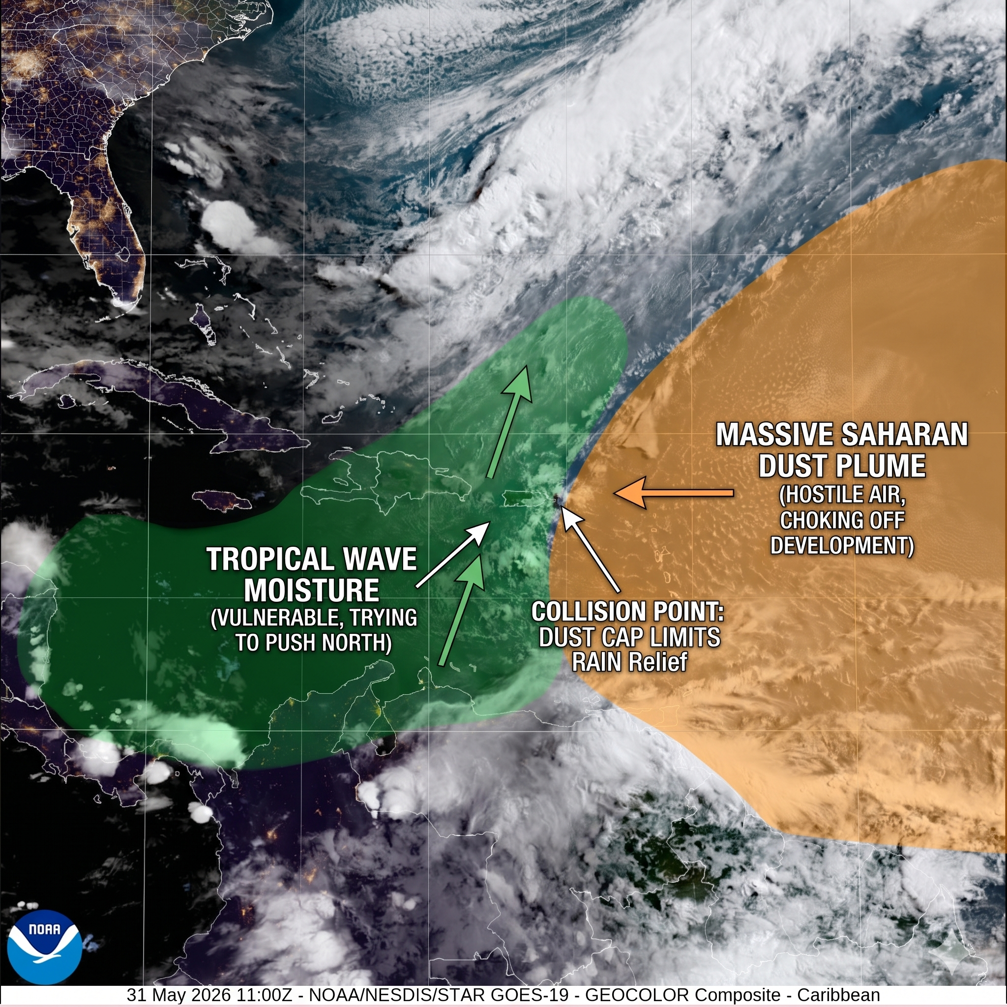
Figure 1: This high-resolution NOAA GOES-19 Geocolor composite, enhanced through AI-driven meteorological data mapping, illustrates the precise boundary line of today's atmospheric conflict over the Virgin Islands. The green-shaded zone highlights vulnerable tropical wave moisture attempting to advance north, while the orange-shaded zone defines the massive, dense perimeter of the hostile Saharan Air Layer as it aggressively caps the atmosphere and chokes off local rain relief. (Graphic: St. Croix Sun / NOAA/NESDIS/STAR)
By JOHN McCARTHY / St. Croix Sun Staff Writer
ST. CROIX — A massive, dense wall of Saharan dust is sweeping across the northeastern Caribbean today, creating a dramatic atmospheric collision directly over the U.S. Virgin Islands. The incoming Saharan Air Layer (SAL) has effectively neutralized a passing tropical wave, choking off potential rainfall and locking in a multi-day stretch of intense heat and hazy skies across the territory.
An Atmospheric Collision Course
The day began with a brief surge of moisture as a weak tropical wave traversed the Caribbean Sea, dropping up to a quarter-inch of rain on St. Croix and parts of eastern Puerto Rico since midnight. Local precipitable water (PWAT) levels peaked near 1.85 inches, briefly fueling hopes for sustained relief from the recent hot conditions.
However, high-resolution NOAA satellite imagery and NASA aerosol tracking data reveal that a robust, continent-spanning plume of African dust has advanced steadily behind the wave. This hostile, bone-dry air mass is rapidly enveloping the local islands. The sheer density of the dust layer is acting as an atmospheric "cap," abruptly dropping relative humidity levels aloft to a desert-like 20 percent and preventing any further vertical cloud growth or thunderstorm development.
What to Expect Through Tuesday
According to the National Weather Service in San Juan, the primary weather impacts through early next week will be environmental rather than precipitation-driven:
Reduced Visibility & Hazy Skies: High concentrations of suspended dust will peak across the local area today through Tuesday, noticeably reducing visibilities across the marine waters and land areas.
Lowered Air Quality: Sensitive groups, particularly individuals with respiratory conditions or asthma, are advised to take precautions and limit strenuous outdoor activities due to high dust concentrations.
Persistent Heat: As the dry air mass fully takes hold, moisture will remain practically non-existent, leaving the region with mostly sunny, hot, and dry conditions. Coastal and urban areas can expect maximum temperatures to hold steady in the mid-to-upper 80s.
Marine and Beach Conditions
While the risk of rip currents remains low today, conditions are forecast to deteriorate by Monday. The Azores high-pressure system will generate moderate to fresh east-to-southeast winds, resulting in choppy regional seas and an increased moderate risk of life-threatening rip currents near reefs, jetties, and piers through much of the week. Marine operators and beachgoers should remain alert to hazy visibilities and strengthening trade winds.
Looking further out, long-range model guidance suggests a brief return to normal seasonal shower patterns by Wednesday, followed by a potential shift toward a more unsettled, wetter weather pattern by next weekend as the next tropical wave approaches. Until then, St. Croix remains firmly locked under a dusty, Saharan shield.