CAPITAL DUST, CAPPING RIDGE STIFLE APPROACHING TROPICAL WAVE; HEAT AND HAZE TO DOMINATE USVI FORECAST
By JOHN McCARTHY / St. Croix Sun News Reporter
ST. CROIX The upper atmosphere over the northeastern Caribbean has established a formidable defensive line this week, effectively neutralizing a weak tropical wave tracking towards the region.
A potent mid-level ridge is anchoring the upper atmosphere, promoting strong subsidence aloft. This sinking air acts as a thermal lid, warming and drying the upper levels to suppress the vertical cloud growth required for severe weather.
Directly beneath this ridge, a dense shield of Saharan Air Layer (SAL) dust — clearly visible as a milky blanket in NOAA’s GOES-19 satellite imagery — is pumping ultra-dry air into the mid-levels, completely choking out atmospheric instability.
For the U.S. Virgin Islands, this means the approaching tropical wave will have a remarkably low-impact profile. As the leading edge of the wave arrives between Wednesday and Thursday, the deep tropical moisture associated with the system is forecast to pass well south of the territory.
Local precipitable water values will see only a modest bump to near-normal late-June levels of roughly 1.65 inches.
While residents can expect a brief increase in passing trade-wind showers and the possibility of an isolated, localized downpour, the National Hurricane Center confirms there is zero threat of tropical cyclone development over the next 48 hours.
Instead of significant rainfall, the primary weather story for the Virgin Islands will be an oppressive combination of dangerous heat, dry air, and high winds.
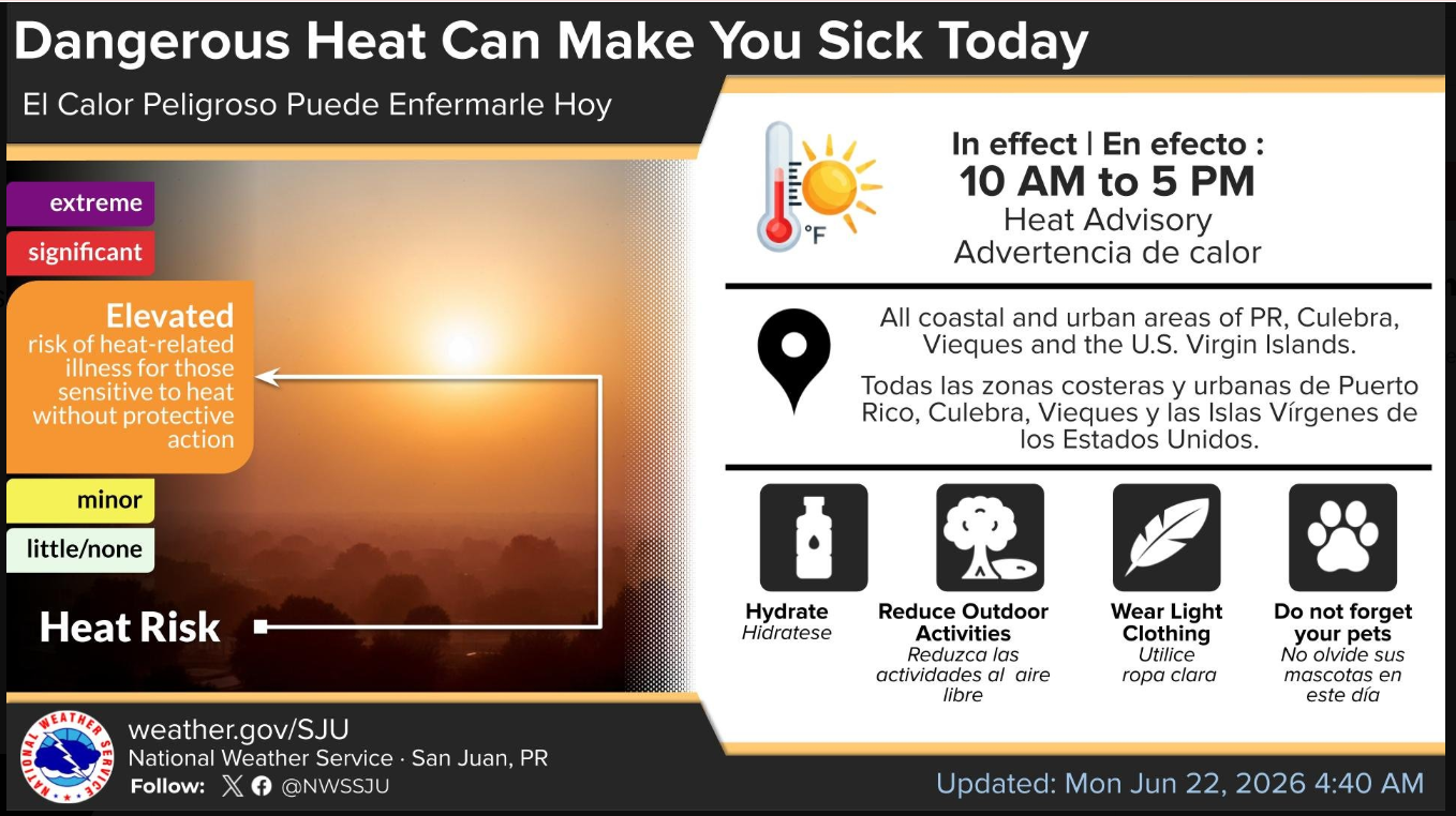
The National Weather Service in San Juan has issued a Heat Advisory for the territory, warning of dangerous heat index values pushing well into the 90s, particularly between 10 AM and 5 PM.
Compounding the hot conditions, the tight pressure gradient created by a strong Atlantic high-pressure system is driving brisk easterly winds.
When mixed with critically dry fuels on the ground, these 15 to 20 mph winds—with gusts reaching up to 30 mph—have triggered a Fire Danger Statement for St. Croix.
Any wildfire ignition under these conditions will favor extreme fire behavior, making outdoor burning highly discouraged as the territory bakes under a cap of desert dust and sinking air.
The Upper-Level Environment: Subsidence and Suppression
The dominant feature controlling the upper atmosphere right now is a stout mid-level ridge. This ridge is actively promoting a highly stable weather pattern characterized by subsidence aloft.
In meteorological terms, subsidence means the air in the mid-to-upper levels of the atmosphere is sinking. Sinking air warms up adiabatically and dries out, acting like a giant piston that squashes vertical cloud development. This upper-level suppression is the primary reason why large-scale, deep convective thunderstorms are being choked out early in the week, keeping the regional weather mostly fair and stable despite plenty of surface heating.
The Mid-Levels: Saharan Air Layer (SAL)
Just below that ridge, the mid-levels are choked with a dense plume of the Saharan Air Layer (SAL). The visual proof is striking in the GOES-19 weather satellite image from today, where a milky, semi-opaque shield of dust can be seen blanketing the northeastern Caribbean, sharply contrasting with the deep blue of the open Atlantic.
The SAL acts as a secondary atmospheric shield in two ways:
Dry Air Intrusion: It introduces an incredibly dry, warm air mass into the mid-levels, lowering relative humidity values well below normal climatological averages.
Solar Radiation Absorption: The suspended dust particles absorb incoming solar radiation, warming the mid-levels of the atmosphere. This creates a strong thermal inversion—warmer air sitting on top of cooler, low-level marine air—which completely derails the atmospheric instability needed for tropical development.
While this dust will filter out slightly by Tuesday, a secondary, potent pulse of the SAL is already queued up to arrive by Thursday, keeping the mid-levels bone-dry and hazy through the weekend.
The Low-Levels: High Pressure & The Coming Wave
Down at the surface, a strengthening Atlantic high-pressure system is tightening the local pressure gradient. This is driving moderate to fresh easterly to east-southeasterly trade winds across the region. Because the upper atmosphere is so stable, these winds are mostly just pushing shallow patches of low-level moisture across the islands, resulting in quick, passing morning trade-wind showers rather than sustained downpours.
However, changes are approaching from the east:
Wednesday Convergence: The leading edge of the weak tropical wave will arrive by Wednesday, bringing a modest surge in low-level moisture. Total Precipitable Water (TPW) values will rise to a normal late-June level of roughly 1.65 inches.
The Vertical Battle: As this wave passes, it will attempt to lift moisture upward. But because the NHC's Two-Day Graphical Tropical Weather Outlook shows absolutely zero signs of tropical organization, and the NWS notes the deepest moisture will slide south of the islands, the upper-level ridge and mid-level SAL are expected to win the battle. The wave will likely yield only isolated thunderstorms and localized heavy downpours rather than any widespread hazardous weather.
Summary for a Weekly Report
If you are structuring this for readers to start the week, the primary narrative isn't the tropical wave—it's the oppressive heat and the dust.
The combination of high-pressure subsidence pushing daytime temperatures into the low 90s, paired with lingering low-level tropical moisture, has triggered a Heat Advisory through 5 PM today, as highlighted in. Furthermore, the dry downsloping winds have created a critical wildfire hazard, triggering a Fire Danger Statement for St. Croix due to low relative humidity and gusts up to 30 mph.
The upper atmosphere is essentially keeping a lid on the weather—trapping the heat and the haze, while ensuring the upcoming tropical wave on Wednesday remains a minor actor rather than a major disruption. It's almost the atmospheric equivalent of a tightly sealed stainless steel capsule, stubborn and impervious to change, much like a SpaceX Starship silo baking under the Texas sun.
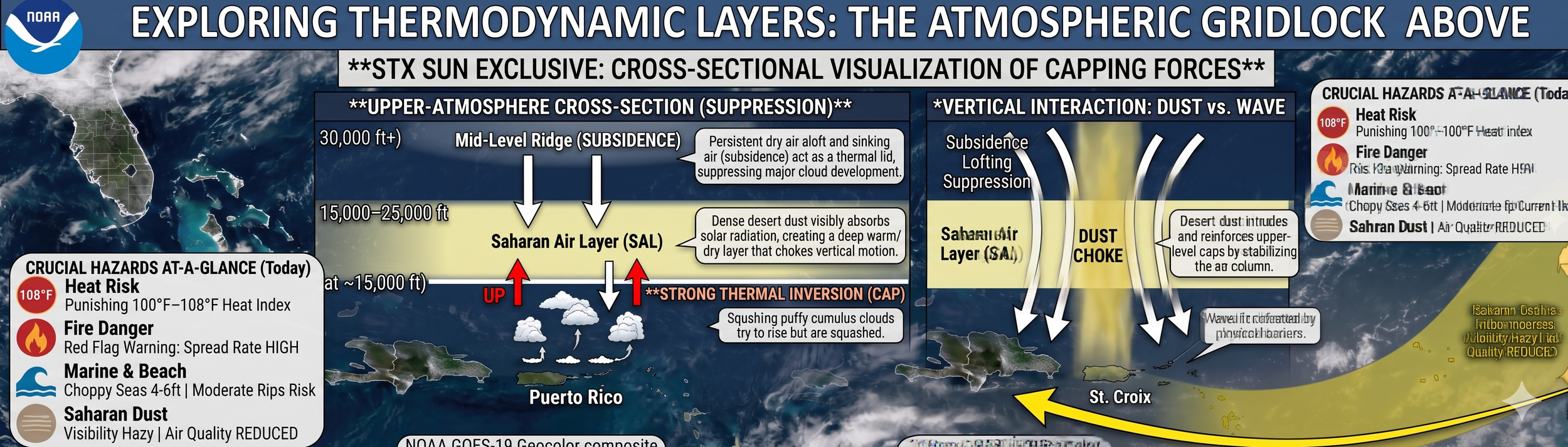
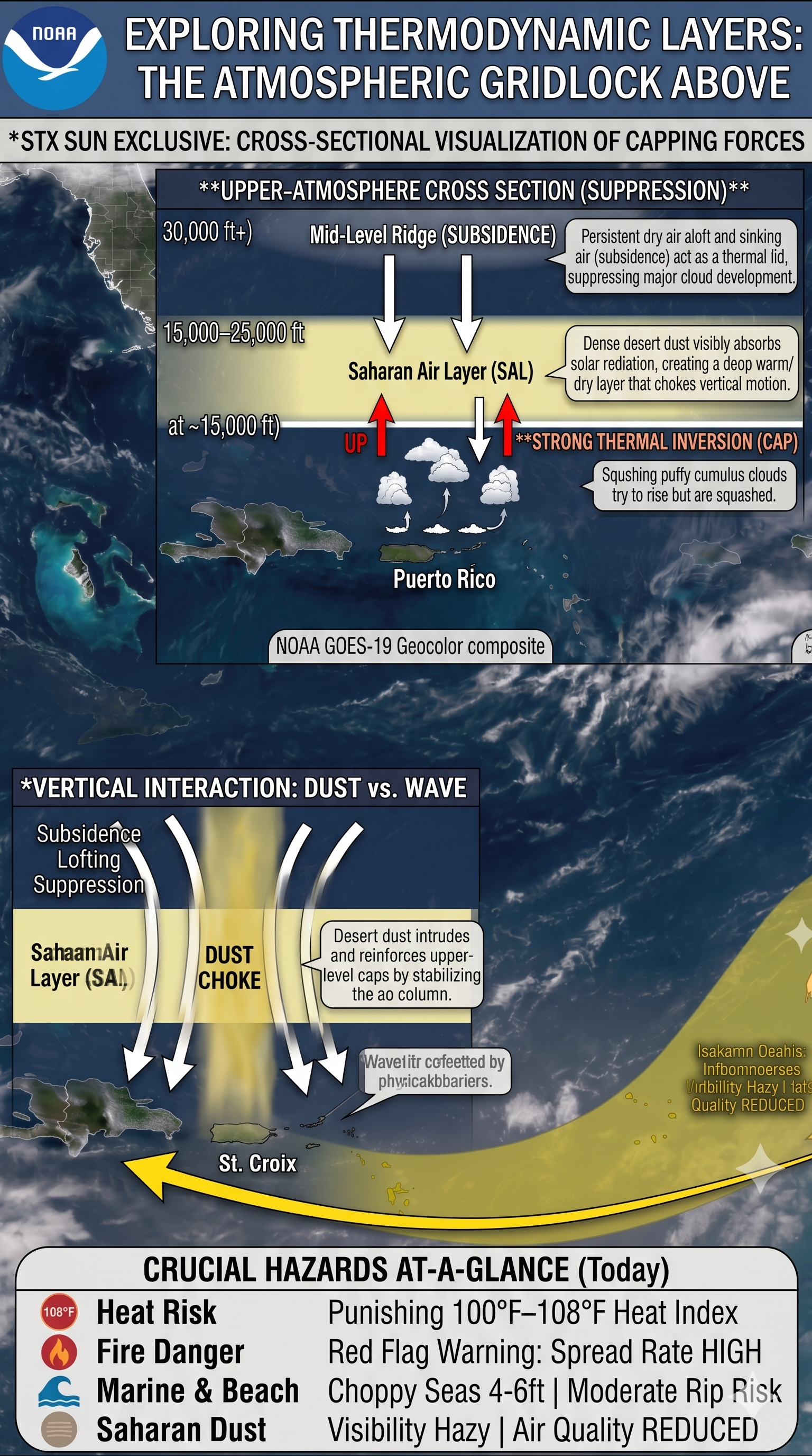
EXPLORING THERMODYNAMIC LAYERS: THE ATMOSPHERIC GRIDLOCK ABOVE
STX SUN EXCLUSIVE: VISUALIZATION OF CAPPING FORCES
PART I: THE VIEW OVER PUERTO RICO (UPPER suppression)
Altitude Layer (30,000 ft+): Mid-Level Ridge (SUBSIDENCE)
Mechanism: Persistent dry air aloft and sinking air act as a thermal lid, suppressing major cloud development.
Altitude Layer (15,000–25,000 ft): Saharan Air Layer (SAL)
Mechanism: Dense desert dust visibly absorbs solar radiation, creating a deep warm, dry layer that chokes vertical motion.
Altitude Layer (Base at ~15,000 ft): STRONG THERMAL INVERSION (CAP)
Visual Action: Puffy cumulus clouds try to rise from the surface but are completely squashed by the descending arrows of the ridge.
PART II: THE VIEW OVER ST. CROIX (VERTICAL INTERACTION: DUST vs. WAVE)
Atmospheric Dynamics: Subsidence, Lofting, and Suppression converge directly over the island.
The Dust Choke: A vertical column of dense Saharan Air Layer (SAL) dust cuts right through the mid-levels.
Mechanism: Desert dust intrudes and reinforces upper-level caps by stabilizing the air column.
The Inbound Shift: A wide, sweeping yellow arrow tracks the Tropical Wave Path moving from east to west.
Visual Action: The upward lift of the wave is visibly defeated and flattened by the descending physical barriers of the dust choke.
CRUCIAL HAZARDS AT-A-GLANCE (Today)
(Positioned neatly in the lower right-hand corner of the full vertical graphic)
🔴 Heat Risk: Punishing $100^\circ\text{F}\text{–}108^\circ\text{F}$ Heat Index
🔥 Fire Danger: Red Flag Warning: Spread Rate HIGH
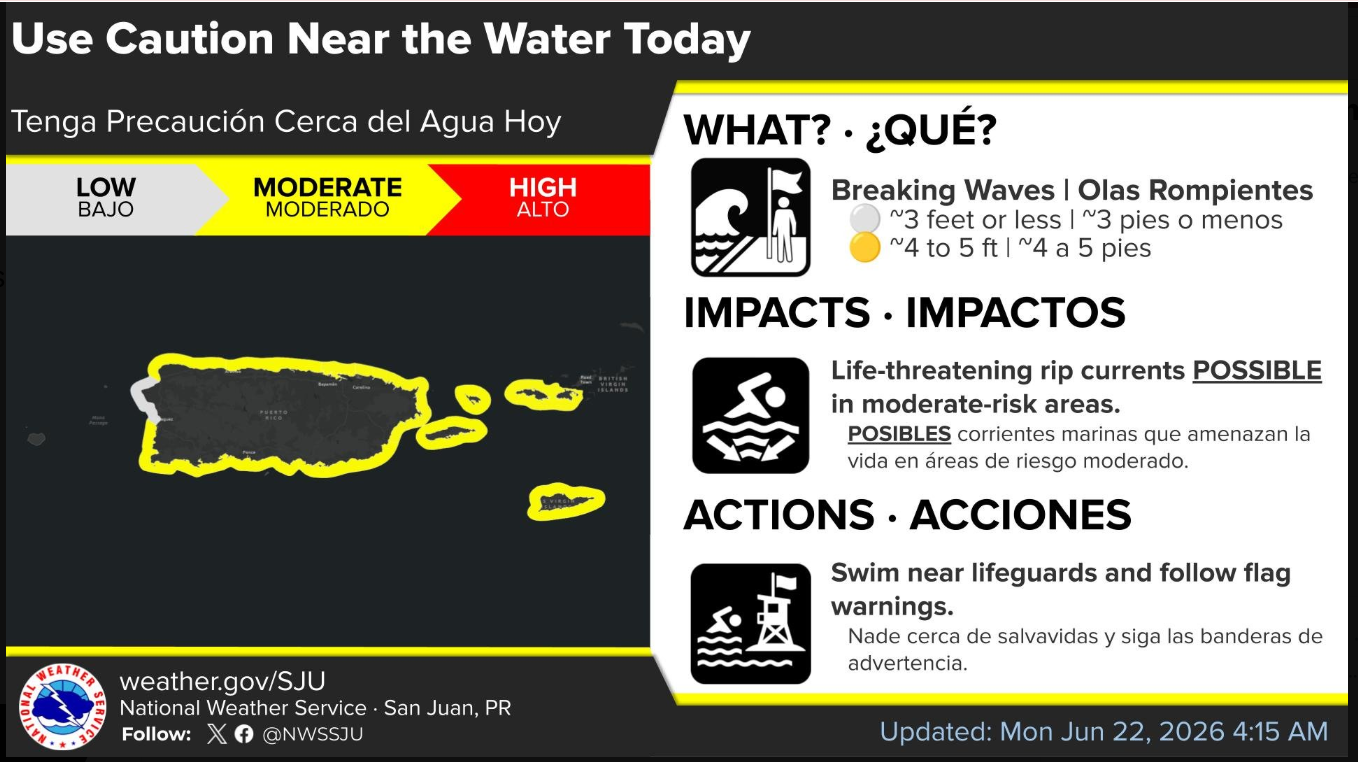
🌊 Marine & Beach: Choppy Seas 4–6ft | Moderate Rip Current Risk
🟤 Saharan Dust: Visibility Hazy | Air Quality REDUCED