
Atmospheric Eviction: Shifting Winds to Temporarily Scrub Saharan Dust Ahead of Midweek Rain
By JOHN McCARTHY / St. Croix Sun Staff Writer
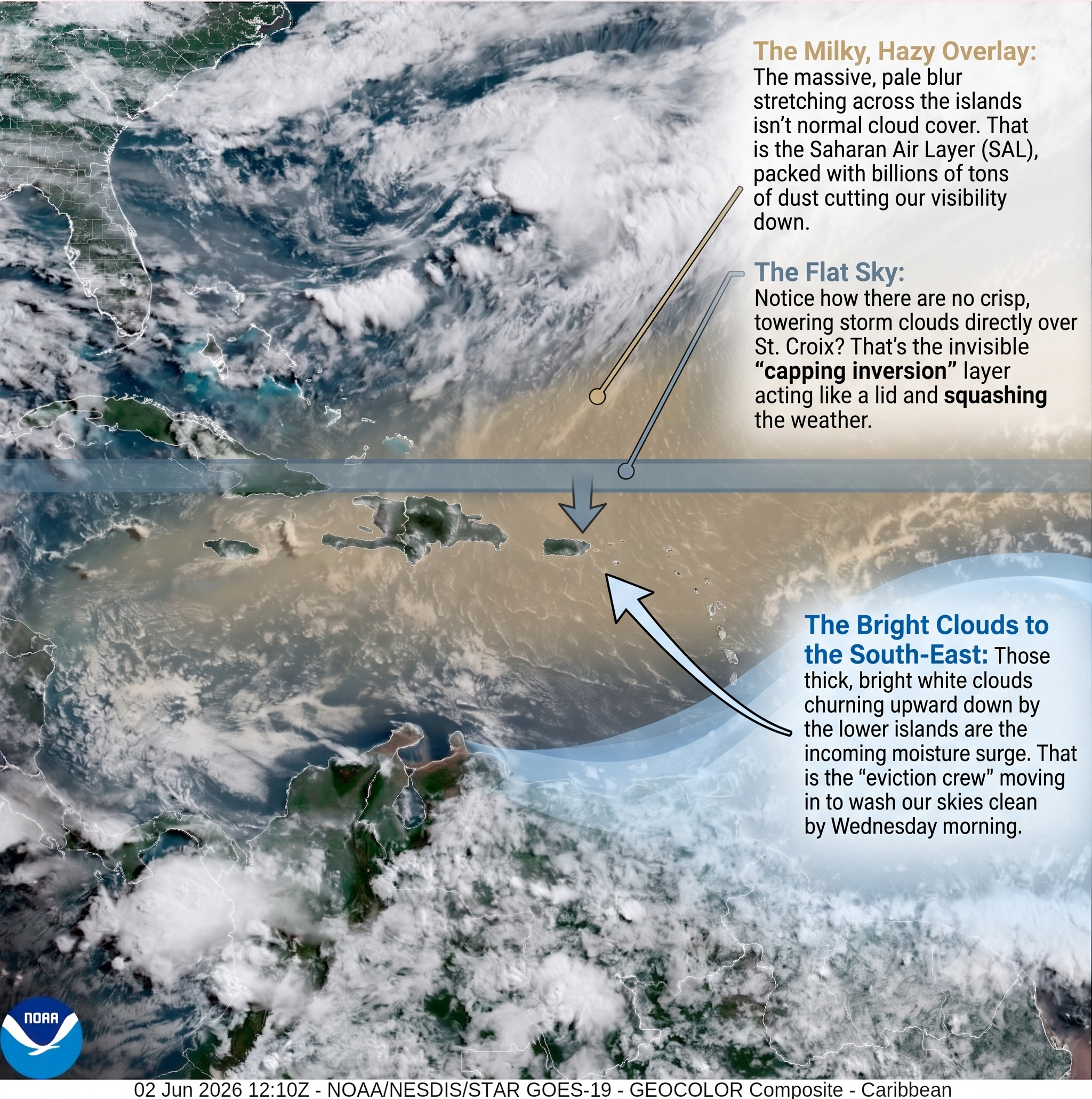
ST. CROIX — To understand why the massive blanket of Saharan dust currently choking the territory is finally packing its bags—at least for a brief moment—we have to look deep into the engine room of the upper atmosphere.
Right now, our tropical sky is completely locked down by a meteorological phenomenon known as a capping inversion. Think of it as an invisible, high-pressure thermal lid sitting a few thousand feet above the islands.
This lid traps the dense, dry Saharan Air Layer (SAL) right over our heads, compressing the dust and suppressing any vertical cloud development.
It is an incredibly stable, stagnant setup that allows the dust to linger, baking the territory in a hazy, hair-dryer heat with indices soaring into the low 100s.
But atmospheric dynamics are never static, and a shifting wind pattern aloft is about to give this dust plume an eviction notice. Sweeping in from the east-southeast, a robust upper-level tropical disturbance is moving into our sector, carrying a massive surge of deep moisture. As this moisture plume arrives late tonight, it introduces a high concentration of precipitable water that begins to rapidly erode that warm thermal lid from the inside out. By cooling the mid-levels of the atmosphere and lifting the capping inversion, the incoming system destroys the very stability the Saharan dust relies on to survive.
This dramatic shift flips the atmospheric script from bone-dry suppression to active, deep convection. As the inversion lifts, the moist air is finally allowed to rise rapidly, forming towering clouds that will trigger widespread showers and localized downpours across the territory on Wednesday. This rainfall acts as a natural scrubbing mechanism, literally washing the suspended dust particles out of the sky and pulling them down to the pavement. It is important to note, however, that this isn't the work of a major tropical storm or a burgeoning hurricane; it is simply a classic, mid-week trade wind disturbance strong enough to punch a temporary hole in the Saharan conveyor belt before the next dusty wave filters back in on Thursday.
The 48-Hour Breakdown
Today (Tuesday): Peak Haze and Heat Expect deep Saharan dust to heavily impact visibility (dropping to 6–8 statute miles) and air quality throughout the day. Winds will remain active out of the east-southeast at 15 to 20 mph, driving daytime highs into the upper 80s and low 90s. Combined with local humidity, heat indices will hover between the upper 90s and low 100s. Rainfall will be strictly limited to brief, shallow morning trade wind showers before the capping inversion locks down the sky. Sensitive groups are urged to limit outdoor exposure.
Tonight into Wednesday: The Moisture Surge Weather conditions will transition dynamically overnight as precipitable water values climb to 1.70 inches. Localized showers will increase significantly in coverage across the U.S. Virgin Islands, bringing projected rainfall accumulations of 0.50 to 1.50 inches. While this moisture will effectively erode the dust layer and clear the haze, ponding on roadways and minor urban flooding are possible during heavy downpours.
Thursday: The Dust Returns The dust-free respite will be short-lived. High-resolution models show a rapid drying trend immediately following Wednesday’s wave, with mid-level humidity plummeting to near 15%. Another distinct plume of Saharan dust is forecast to filter back over the region, restoring hazy skies, dry conditions, and suppressed rainfall just in time for the weekend.
Maritime and Beach Warning
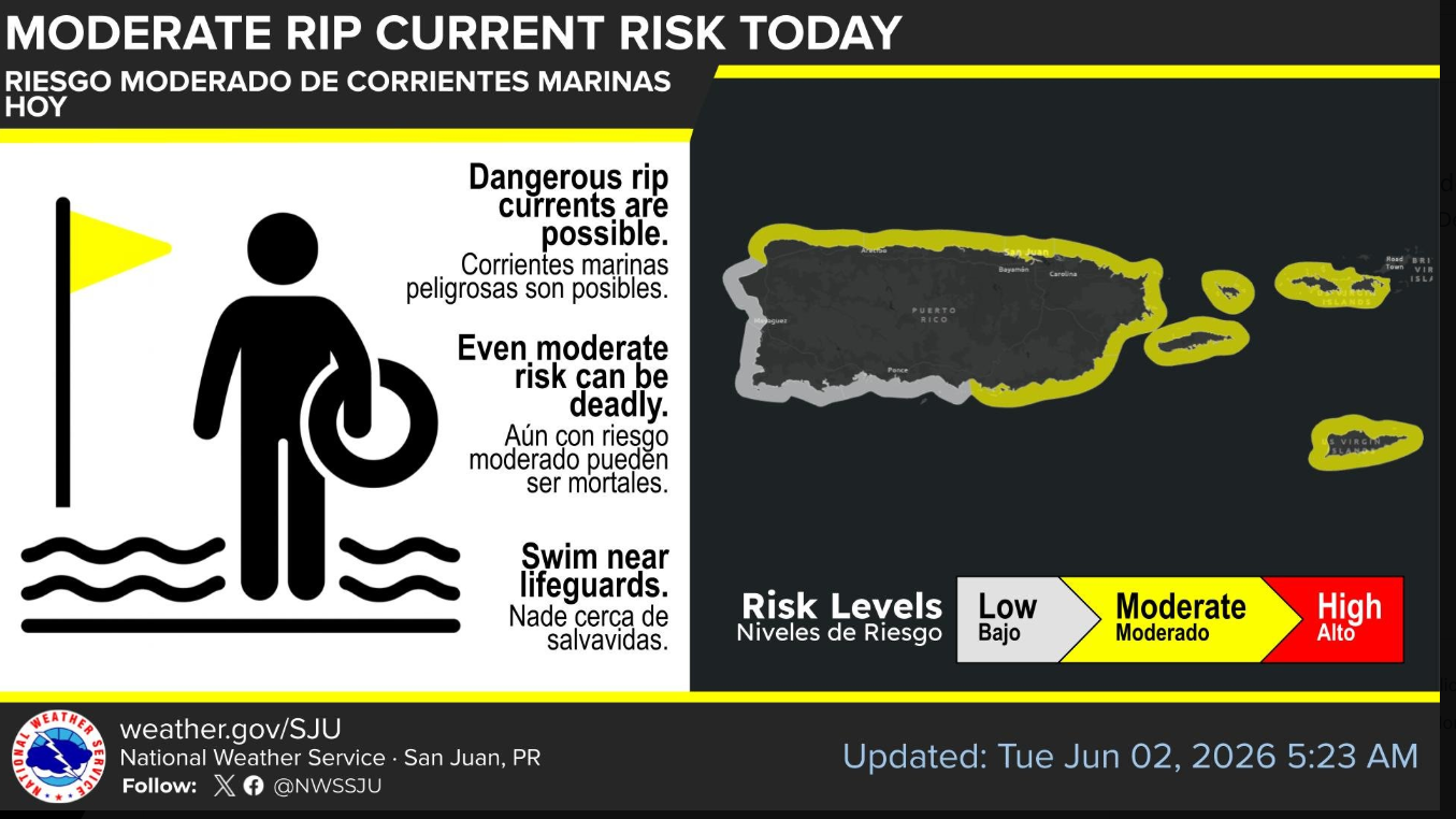
A tightened local pressure gradient will continue to generate moderate to fresh winds, causing choppy marine conditions across regional waters all week. The National Weather Service in San Juan has issued a Moderate Rip Current Risk for today, meaning life-threatening rip currents are entirely possible. Swimmers and beachgoers are strongly advised to exercise caution and heed all local flag warning systems.
🌫️ Today: Peak Dust and Capped Skies
We are gridlocked in the heaviest, densest chunk of this current Saharan Air Layer (SAL) plume. If you look at the GOES-19 satellite image you provided, that milky, indistinct haze stretching across the northeastern Caribbean represents an incredibly dry, stable air mass completely choking out significant cloud development.
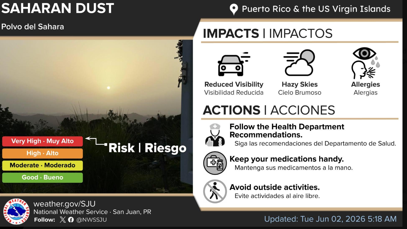
The Air Quality & Visibility: The National Weather Service in San Juan has pinned the Saharan Dust risk at "High" for today. Visibility across regional aviation terminals is dropping down to 6–8 statute miles. For anyone with respiratory sensitivities, today is the absolute peak day to remain indoors and keep medications handy.
The Thermometer: Winds out of the east-southeast at 15 to 20 mph are acting like a hair dryer, dragging high temperatures into the upper 80s and lower 90s. With humidity factored in, expect heat indices to easily sit between the upper 90s and low 100s.
Rain Chances: Essentially zero for the afternoon. A powerful "capping inversion" (a layer of warm air aloft acting like a literal lid) is completely suppressing deep convection.
🌧️ Tomorrow (Wednesday): A Window to Run Errands?
For anyone running errands tomorrow, you are in luck—but with a major catch.
The dense dust layer is going to get dynamically scrubbed out late tonight into Wednesday by an incoming surge of deep tropical moisture. Total precipitable water (PWAT) values are leaping from a bone-dry 1.0 inch today up to a juicy 1.70 inches tomorrow.
The Good News: This moisture surge will completely erode the heavy dust layer, giving your lungs a massive break and clearing up the hazy skies.
The Bad News: It is replacing the dust with rain. High-resolution models are universally projecting an island-wide increase in shower coverage, with localized rainfall totals of 0.50 to 1.50 inches across the territory.
The Errand Strategy: If you need to run around St. Croix tomorrow, pack an umbrella, keep an eye out for localized low-lying street flooding, and monitor WAPA's grid. A sudden transition from heavy dust settling on transformers to heavy downpours is historically prime territory for local line trips.
🌊 Marine & Beach Outlook: Double Hazard
If you are tracking maritime traffic or looking out at the harbor, keep in mind that conditions are a bit treacherous right now.
Rip Currents: Strong east-to-southeast trade winds have triggered a Moderate Rip Current Risk across almost all regional beaches in the USVI and Puerto Rico. A small northerly swell is also mixing into the local waters tonight into Wednesday, keeping the surf choppy and unpredictable.
On the Water: The surface high pressure system is tightening the local gradient, creating fresh, breezy conditions on the water that will persist through much of the week.
🔭 The Extended Outlook (Thursday & Beyond)
Enjoy the clear, wet respite on Wednesday, because by Thursday, a rapid and aggressive drying trend slams the door shut again. A secondary pulse of moderate Saharan dust will filter back over the Virgin Islands, plunging mid-level humidity down to a desert-like 15% and keeping things hazy and dry right through the weekend.
Essentially, nature is running a strict alternating schedule this week: Tuesday is Dust, Wednesday is Rain, and Thursday right back to Dust. Stay cool out there today, keep the AC running if the power permits, and get ready for a damp dash through your errands tomorrow!