BOILING POINT: Triple-Digit Heat Indices and Choppy Seas Greet Cruise Ships as Memorial Day Deluge Pools in the Atlantic
By JOHN McCARTHY / St. Croix Sun Staff Writer
FREDERKSTED - The morning sun over St. Croix breaks across a vibrant, deep blue harbor today, welcoming a massive cruise liner to port and signaling a bustling start to the workweek.
For the hundreds of visitors stepping onto the docks, the day promises plenty of classic Caribbean sunshine, though it comes with a noticeable edge of late-spring heat.
A brief band of early morning moisture that brought scattered showers across the U.S. Virgin Islands is rapidly giving way to a pocket of drier air moving in from the east, ensuring that clear skies will dominate the peak hours of the day.
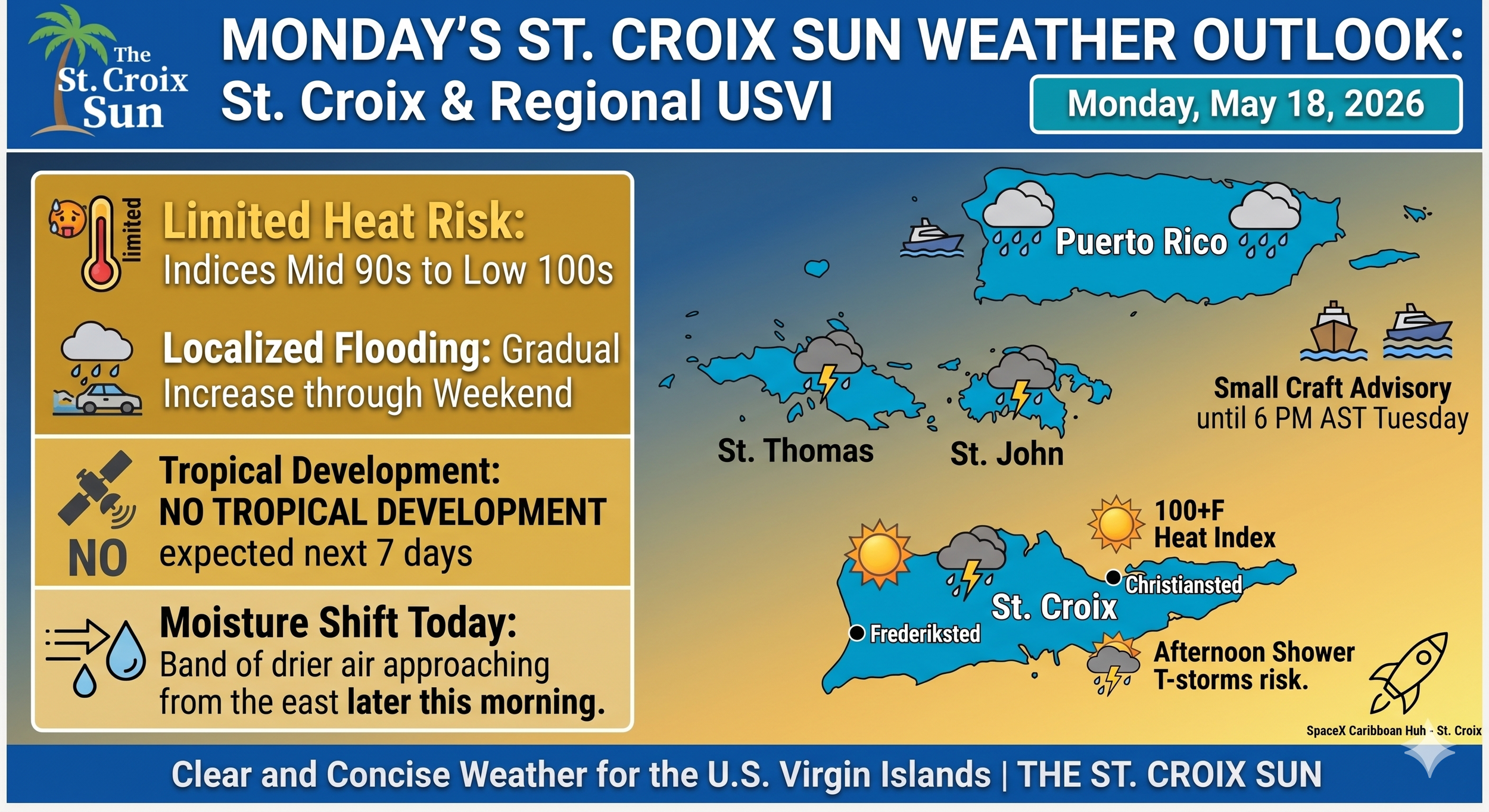
However, anyone heading out to explore the historic streets or hit the beaches will want to seek out some shade and carry plenty of fresh water. While actual air temperatures are forecast to sit comfortably in the upper 80s to lower 90s, the lingering tropical humidity is expected to drive afternoon heat indices into the mid-90s and low 100s. Combined with a persistent, breezy trade wind, the local waters will remain somewhat choppy, carrying a moderate risk of rip currents along the territory's coastlines through the next several days.
Looking deeper into the week, this breezy and warm pattern is expected to hold firm as we approach the upcoming Memorial Day holiday weekend. A shifting high-pressure system over the Atlantic will maintain moderate to fresh easterly winds, but weather models suggest that deeper tropical moisture will begin to pool over the region by Friday. This setup, paired with a developing upper-level disturbance, means that while the first half of the week offers great outdoor conditions, localized shower activity and the risk of urban ponding will steadily increase just in time for the long weekend.

COMMERCE AT THE DOCK: Royal Caribbean’s Rhapsody of the Seas makes its morning approach to the Ann E. Abramson Marine Facility at the Frederiksted Pier on Monday. (St. Croix Sun Photo by JOHN McCARTHY)
🌤️ Weather Forecast Overview
Morning & Afternoon: We started the day with some passing bands of moisture bringing quick, light showers. However, a band of drier air is moving in from the east, which should clear things up and provide plenty of sunshine for the visitors during peak daytime hours.
The Heat is On: It is going to feel quite warm out there. While actual highs will be in the upper 80s to lower 90s, the humidity will push heat indices into the mid 90s to low 100s. Guests should definitely pack water and sunscreen.
Late Afternoon: As the day winds down, there is a limited risk of isolated afternoon showers or a stray thunderstorm developing downwind of the local islands, but the heaviest inland flooding risks are concentrated over interior and western Puerto Rico.
🌊 Marine & Beach Conditions
If any of today's tourists are planning to head to the beach or book a boat excursion, they'll want to keep an eye on the water:
Choppy Seas: A strong high-pressure system over the Atlantic is keeping trade winds breezy. While the Small Craft Advisory is specifically for the offshore Atlantic waters, local seas will remain on the choppy side.
Rip Current Risk: There is a moderate risk of rip currents for the U.S. Virgin Islands. It’s still fine for swimming, but visitors should stick to guarded beaches and exercise caution.