Brutal 108°F Heat and Choking Saharan Dust Team Up to Put the Squeeze on the USVI
By JOHN McCARTHY / St. Croix Sun News Reporter
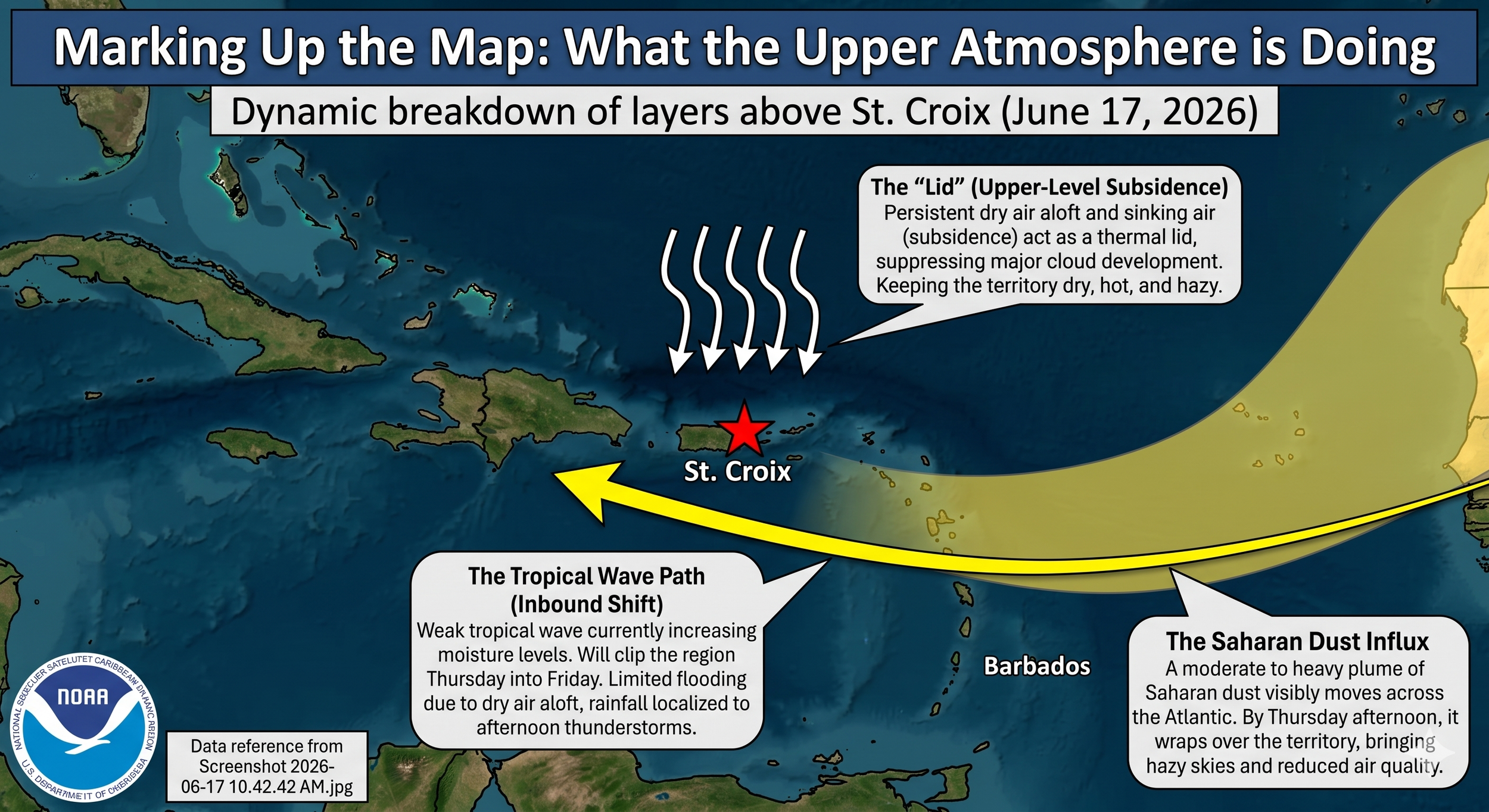
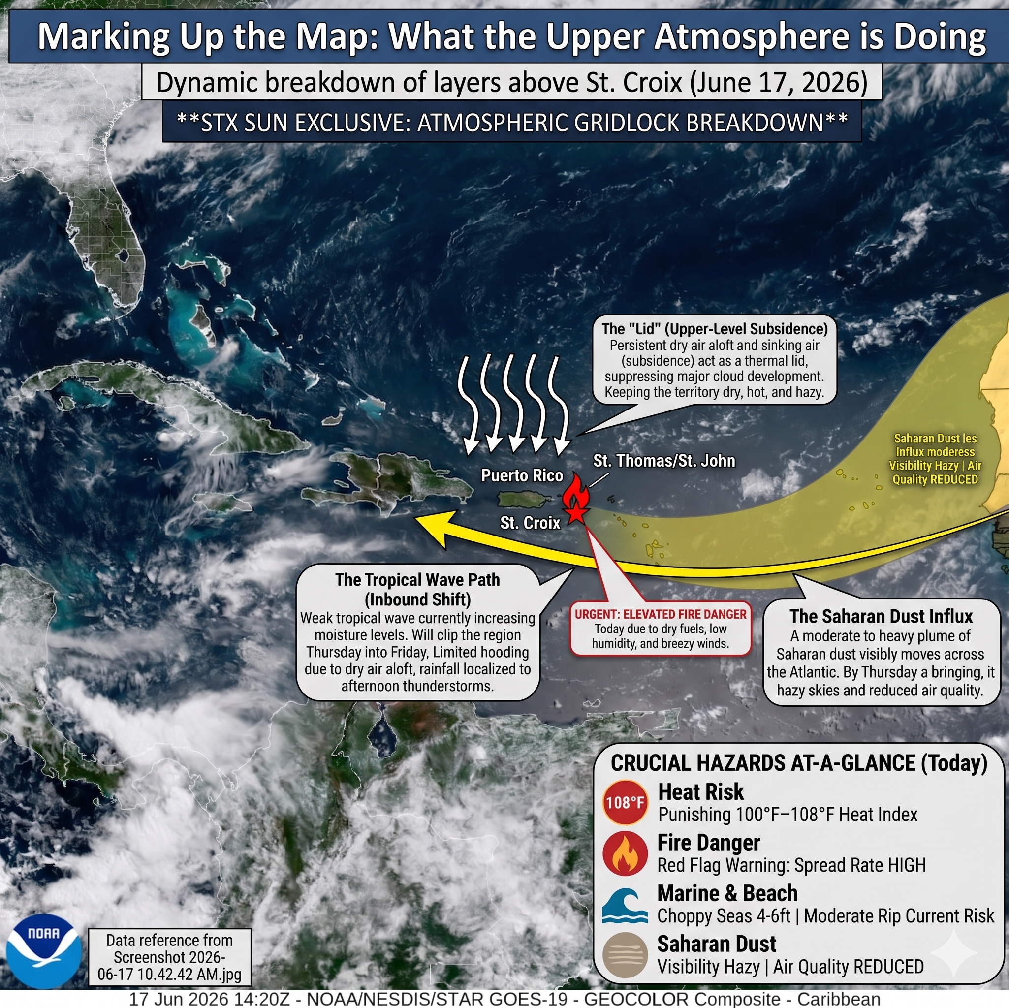
ST. CROIX — A look at the upper atmosphere reveals a powerful meteorological tag-team currently locking the U.S. Virgin Islands into a pattern of intense heat, hazy horizons, and dry conditions. High above the Caribbean, a persistent mid-level ridge of high pressure remains firmly entrenched, acting as a heavy atmospheric lid. This ridge creates a continuous sinking motion in the air, known as subsidence. As the air sinks, it warms and dries out, effectively squashing any cloud development before it can gain enough vertical height to produce meaningful rainfall.
Coinciding with this high-altitude suppression is a massive, sweeping plume of Saharan dust tracking directly across the tropical Atlantic. This layer of dry, dust-laden air sits in the mid-levels of the atmosphere, serving as an effective shield against tropical development. While this hostile upper-air environment is successfully tearing apart convective activity—forcing a weak tropical wave to slide harmlessly far to our south over the Caribbean Sea—it comes with a stifling cost on the ground. The combination of intense June sunshine, compressed air beneath the ridge, and the thermal properties of the dust layer is driving localized afternoon heat indices well past 100°F, with exposed areas of the territory bracing for heat indices that could climb as high as 108°F today.
Looking ahead into the workweek, the upper-level steering currents will maintain a moderate to fresh east-to-southeast trade wind flow, dragging choppy 4 to 6 foot seas across our local passages and maintaining a persistent rip current risk along exposed beaches. Atmospheric models suggest that by Thursday and Friday, moisture associated with the passing tropical wave will increase slightly across the region. However, moisture levels are expected to remain near seasonal normals, while persistent dry air aloft and the building Saharan dust plume will continue to limit widespread rainfall coverage and intensity.
While this shift on the horizon will open the door for a modest increase in low-level moisture and brief passing showers toward the weekend, local readers shouldn't expect a drought-breaker. The sheer volume of mid-level dry air and lingering Saharan dust will continue to choke out major storm intensity, keeping the territory firmly under a hot, breezy summer pattern for the foreseeable future.

Crucial Hazards At-A-Glance
Heat Risk: Expect stifling conditions as afternoon heat indices regularly climb past 100°F, with urban and low-lying areas across the region threatening to hit or exceed 108°F today.
Marine & Beach Conditions: Breezy trade winds are keeping local waters choppy, with seas running 4 to 6 feet across offshore waters and local passages. A Moderate Risk of rip currents remains active for most exposed, east-facing beaches.
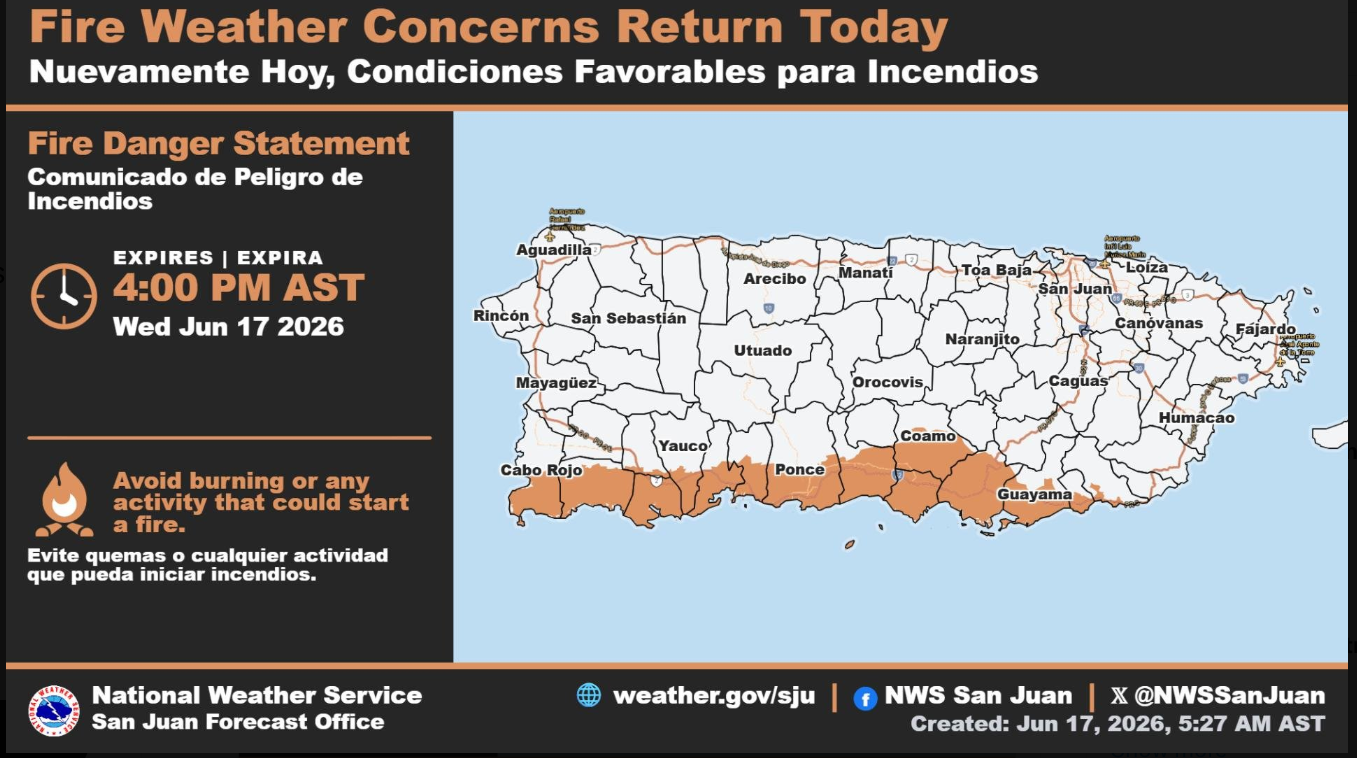
Fire Danger: Critically dry fuels, low relative humidity, and breezy winds have elevated the risk of fire danger today. Any brush fires that develop could spread rapidly before rain relief arrives.
Saharan Dust: A moderate concentration of Saharan dust is arriving by Thursday afternoon. Expect increasingly hazy horizons and reduced air quality late in the week.

Marine and Surf Outlook
The National Weather Service in San Juan has noted that Small Craft Exercise Caution conditions are in play due to the fresh trade winds.
Beach Safety Note: Life-threatening rip currents are a distinct possibility along exposed coastlines today. If you are heading to the water, prefer protected beaches, stay mindful of local warning flags, and remember the golden rule: If in doubt, stay out.
Wind Conditions: Persistent east to east-southeast trade winds will blow at 15 to 20 knots, with higher localized gusts expected near exposed coastal areas and near any isolated shower activity.
The Extended Outlook: Watching the Horizon
A weak tropical wave is currently tracking through the Caribbean, but it is projected to stay well south of the Virgin Islands, offering zero meaningful relief from the dry spell over the next 24 hours.
By Thursday into Friday, model guidance points towards a modest increase in moisture as the wave clips the region. The trade wind cap will weaken slightly, bringing a minor increase in shower activity and the potential for an isolated thunderstorm. However, the arriving Saharan dust and deep mid-level dry air will likely choke out any heavy or prolonged downpours, meaning our significant regional rainfall deficits will persist into the upcoming weekend.