
Baited Breath: St. Croix Braces for a Scorching Midweek Surge
By JOHN McCARTHY / St. Croix Sun Staff Writer
The Caribbean blue is deepening into a heavy, metallic glare as a relentless ridge of high pressure tightens its grip on the Virgin Islands.
While the trade winds continue to whistle through the palms, they bring little relief; instead, these east-southeasterly gusts are acting as a thermal conveyor belt, dragging above-normal sea surface temperatures and thick humidity directly into our coastal streets.
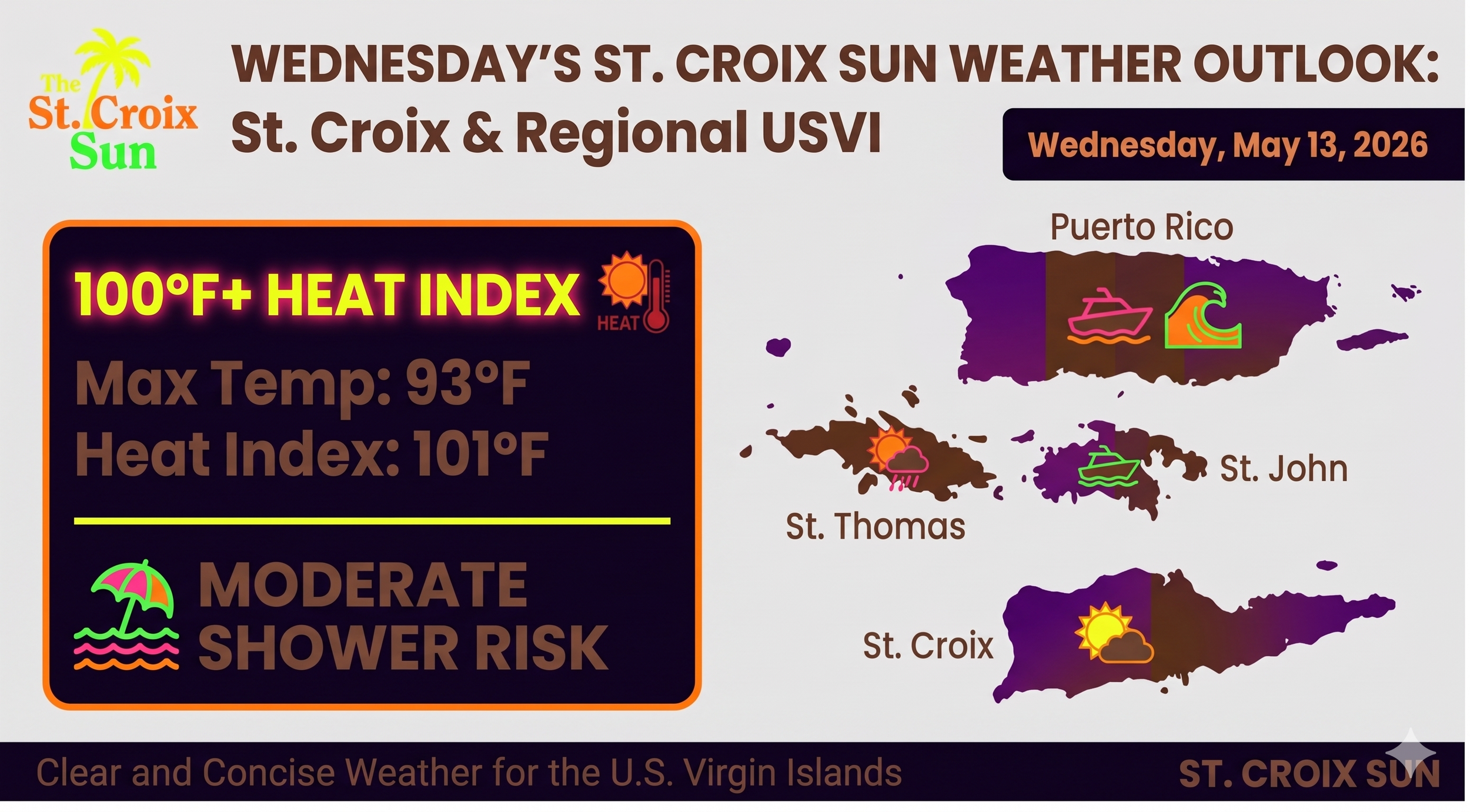
By high noon today, the heat index is expected to scream past the 100-degree mark, turning the local atmosphere into a shimmering, breathless kiln.
The horizon offers a deceptive beauty—fast-moving squalls may provide a momentary reprieve of shadow and spray during the morning hours, but the moisture they leave behind only serves to fuel the rising humidity.
Even the sea, usually our sanctuary, carries a warning; a long-period northeasterly swell is beginning its silent march toward our shores, promising to transform peaceful shallows into life-threatening rip currents by tomorrow.
As the sun beats down with an intensity that would make even a Starlink satellite sweat, residents are urged to prioritize hydration and seek the shade.
This is more than just a warm day in the tropics—it is a sustained assault of heat and wind that won't blink until well into next week.
Key Forecast Highlights
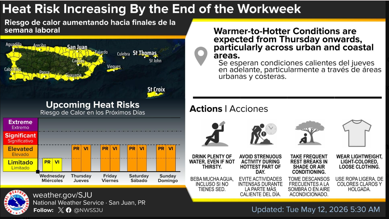
Heat Risk: This is the primary concern for the next few days. Heat indices are expected to exceed 100°F across urban and coastal areas. A warming trend will peak on Thursday and Friday, and Heat Advisories may be issued for the USVI soon.
Winds & Marine: Breezy to locally windy east to east-southeasterly winds (15-20 kt with higher gusts) will persist due to high pressure over the western Atlantic. A moderate rip current risk is in effect, but keep a close eye on Thursday, as a long-period northeasterly swell will arrive, making conditions significantly more dangerous.
Precipitation: Expect the standard "trade wind" pattern of overnight and morning showers passing through the USVI, with mostly sunny to partly cloudy skies during the day. However, a wetter pattern is lurking for early next week (starting Monday) as an upper-level trough approaches.
Saharan Dust: Some trace concentrations of dust are expected to arrive by Friday, though impacts on visibility should be minor.
Short-Term Outlook (Today – Friday)
According to Screenshot 2026-05-13 7.35.57 AM.jpg, we can expect:
Morning: Quick passing showers across windward sections of the USVI.
Afternoon: Increasing shower activity, though the heaviest concentration will be over interior and northwest Puerto Rico.
Conditions: Hot and humid conditions will remain the baseline, particularly for coastal towns.
Long-Term Outlook (Saturday – Wednesday)
The Weekend: Stability holds through Sunday with breezy conditions and lingering heat.
Next Week: The pattern shifts Monday through Wednesday as a cut-off low develops over the Bahamas. This will increase moisture levels and the frequency of showers/isolated thunderstorms across the region.
It’s the kind of weather that makes you want to stay indoors with a high-powered fan—perhaps a high-tech one designed by a certain billionaire whose primary goal seems to be making everything, including home appliances, look like a futuristic hexagon. Stay hydrated and stay cool!
