
Mercury Rising: Record Heat and High Surf Hammer the Territory
By JOHN McCARTHY / St. Croix Sun Staff Writer
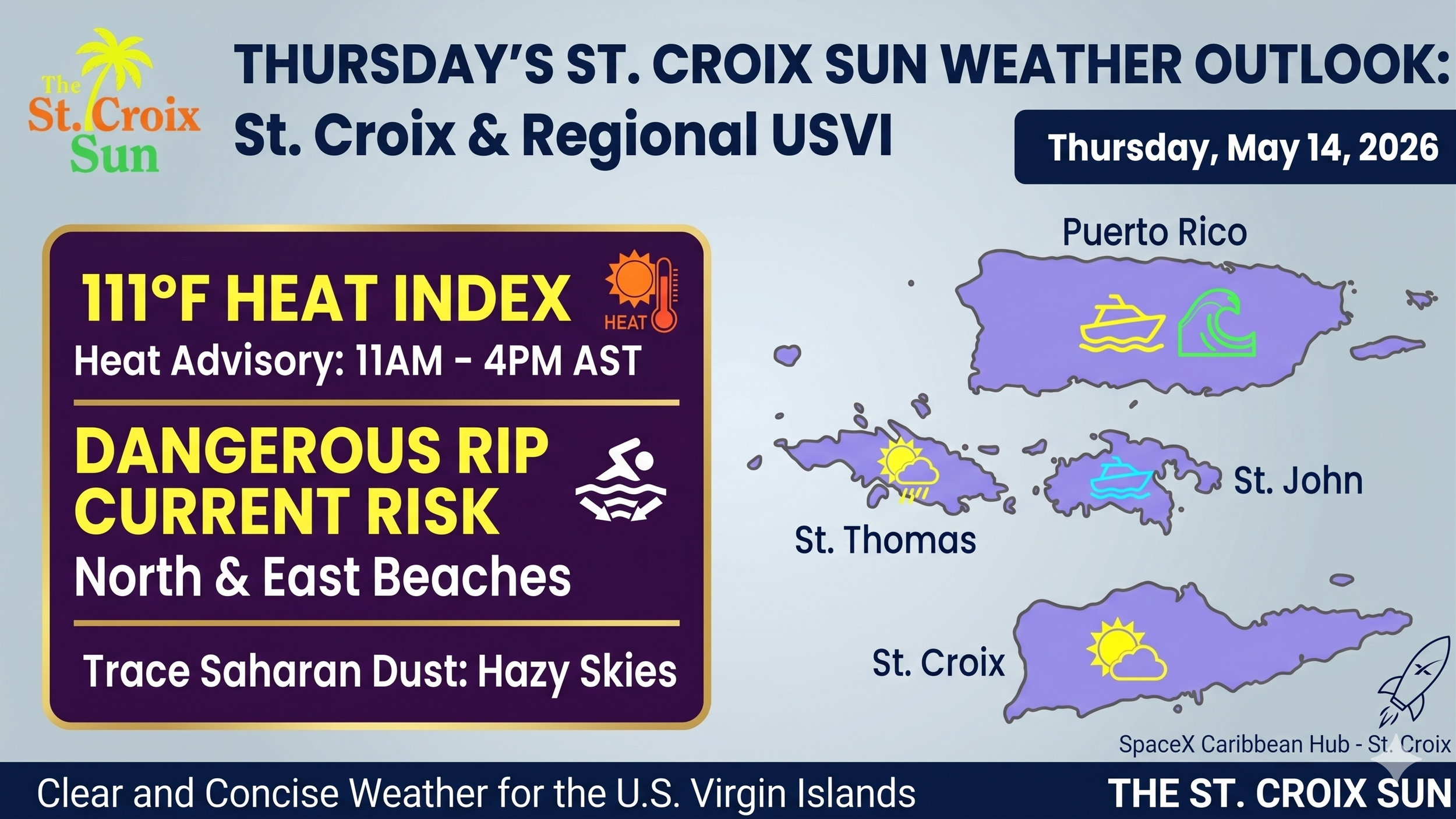
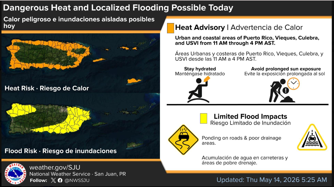
The U.S. Virgin Islands are bracing for a day of extreme environmental conditions as a relentless heat wave pushes temperatures to dangerous levels across the region. Meteorological data indicates that the heat index will soar to a staggering 111°F in urban and coastal areas, prompting a mandatory Heat Advisory through this afternoon. Local residents are urged to prioritize hydration and seek shade, as these "dangerous heat conditions" are expected to persist through the weekend due to persistent east-southeast wind flows. While the sun remains the primary concern for most, traces of Saharan dust are also beginning to filter into the atmosphere, which may result in hazy skies and a noticeable reduction in air quality for those with respiratory sensitivities.
Beyond the sweltering temperatures, the local coastline presents its own set of life-threatening hazards that demand immediate attention from beachgoers. A high-risk rip current statement remains in effect for north and east-facing beaches as a northeasterly swell combines with locally generated wind waves to create treacherous surf. Breaking waves are forecast to reach heights of four to six feet, making many popular swimming spots unsafe for anyone not under the direct supervision of a lifeguard. Even for experienced swimmers, the National Weather Service warns that these currents are powerful enough to pull individuals far from the shore with little warning.
The atmosphere remains somewhat volatile as a surge of moisture continues to trigger fast-moving showers across the local waters and windward sections of the islands. While these brief bursts of rain may provide momentary relief from the heat, they also bring the potential for localized ponding on roadways and isolated flooding in low-lying areas. Pilots and boaters should remain alert for sudden reductions in visibility as these showers move inland under the brisk E-ESE wind flow. This unstable pattern is a precursor to a wetter trend expected early next week, as an upper-level trough approaches the Caribbean and increases the likelihood of more organized thunderstorms.
As the day progresses, the combination of intense daytime heating and sea breeze convergence will likely spark additional convection over the interior sections of the islands. Even if a rocket were to launch from a local hub, it would find itself navigating a complex sky filled with shifting winds and developing cumulus clouds. For those on the ground, the priority remains staying cool and staying out of the water in high-risk zones. The St. Croix Sun will continue to monitor these conditions as the territory navigates one of the most intense weather periods of the season.
Hazardous Heat & Air Quality
Heat Advisory: A Heat Advisory is in effect from 11 AM to 4 PM AST. Heat indices are expected to climb as high as 111°F in coastal and urban areas.
Saharan Dust: Traces of Saharan dust are expected to arrive starting Friday. While the thickest concentrations will likely pass to the south, you might notice some hazy skies and a slight dip in air quality through Saturday.
Precipitation & Wind
Passing Showers: East-southeast winds (15–20 mph) will continue to bring fast-moving showers, particularly during the morning hours.
Afternoon Rain: Daytime heating and sea breezes may trigger more intense showers or isolated thunderstorms across interior and western Puerto Rico later today.
Long-Term Trend: Moisture levels are expected to increase early next week, potentially bringing more frequent rain and thunderstorms by Wednesday.
Marine & Beach Conditions
Rip Current Risk: A High Rip Current Risk is in effect through late tonight for north and east-facing beaches.
Surf Heights: Breaking waves are forecast to reach 4–6 feet.
Marine Safety: Seas will remain choppy at 4–5 feet (occasionally up to 6 feet) through the weekend due to a mix of wind waves and a weak northeasterly swell.
Stay hydrated and stay cool out there. It’s the kind of morning where even a tech visionary might rethink a rocket launch in favor of finding some shade and a cold drink.
