THE INVISIBLE THREAT: Why St. Croix’s Refreshing Trade Winds Are Deceiving Outdoor Workers Today
By JOHN McCARTHY / St. Croix Sun Staff Writer
CHRISTIANSTED — The unrelenting late-May sun continues to dominate the atmospheric narrative across the U.S. Virgin Islands, turning the routine act of stepping outdoors into a calculated test of endurance.
A tight pressure gradient driven by a powerful high-pressure system over the central Atlantic is channeling a steady, blustery easterly breeze across the territory.
While these strong trade winds provide a deceptive momentary relief, they are simultaneously whipping up the surrounding waters, keeping offshore seas rough.
These choppy seas will make for a moderate rip current risk along our north and east-facing beaches.
For the next several days, this pattern will hold fast: a brilliant, high-glare sky occasionally interrupted by fast-moving, windward showers.
These steamy showers will rattle against our pre-heated rooftops and disappear as quickly as they arrived, leaving a fresh layer of humidity in their wake.
As we head into the upcoming holiday weekend, the primary meteorological story isn't the threat of rain, but rather the cumulative weight of the heat. The National Weather Service notes that while actual ambient temperatures will sit in the upper 80s to low 90s, the moisture-laden tropical air mass will push real-feel heat indices consistently between 100 and 105 degrees Fahrenheit. This intense thermal load is expected to peak over the next few days, offering very little atmospheric cooling even as wind speeds occasionally gust over 20 knots. The sheer consistency of this heat profile means the environment absorbs and retains warmth throughout the day, creating an oppressive baseline that heavily taxes the physical stamina of anyone exposed to the elements for more than a brief interval.
While the gaze of the island often turns to the open ocean, where the glaring reflection of the sun off the water presents its own blinding challenges, a different kind of endurance is required for those anchored to the asphalt and bedrock. For construction crews framing new structures or Department of Public Works teams executing essential road repairs, the environment is doubly hostile. These workers do not just contend with the ambient solar radiation from above; they are caught in a thermal vise, absorbing heat radiating upward from black asphalt, pouring concrete, and heavy machinery. On days like today, managing this exposure requires moving beyond basic hydration toward a deliberate strategy of heat mitigation.
To beat the heat under such grueling conditions, local crews have to rely on structured adjustments to their operational rhythm. Foremen and site managers are increasingly shifting heavy labor to the earliest possible hours of dawn, saving less strenuous tasks for the peak radiation hours of midday. Establishing designated, shaded cooling zones on-site—equipped with active ventilation or misting setups—allows the core body temperature to drop during mandated rest breaks before reaching critical levels. Furthermore, shifting the hydration focus from plain water to electrolyte-replenishing fluids is vital to counter the heavy loss of essential minerals through continuous sweat. In an environment where the heat index refuses to break, treating thermal safety as a strict, engineered protocol is the only way these essential outdoor crews can successfully outlast the elements.
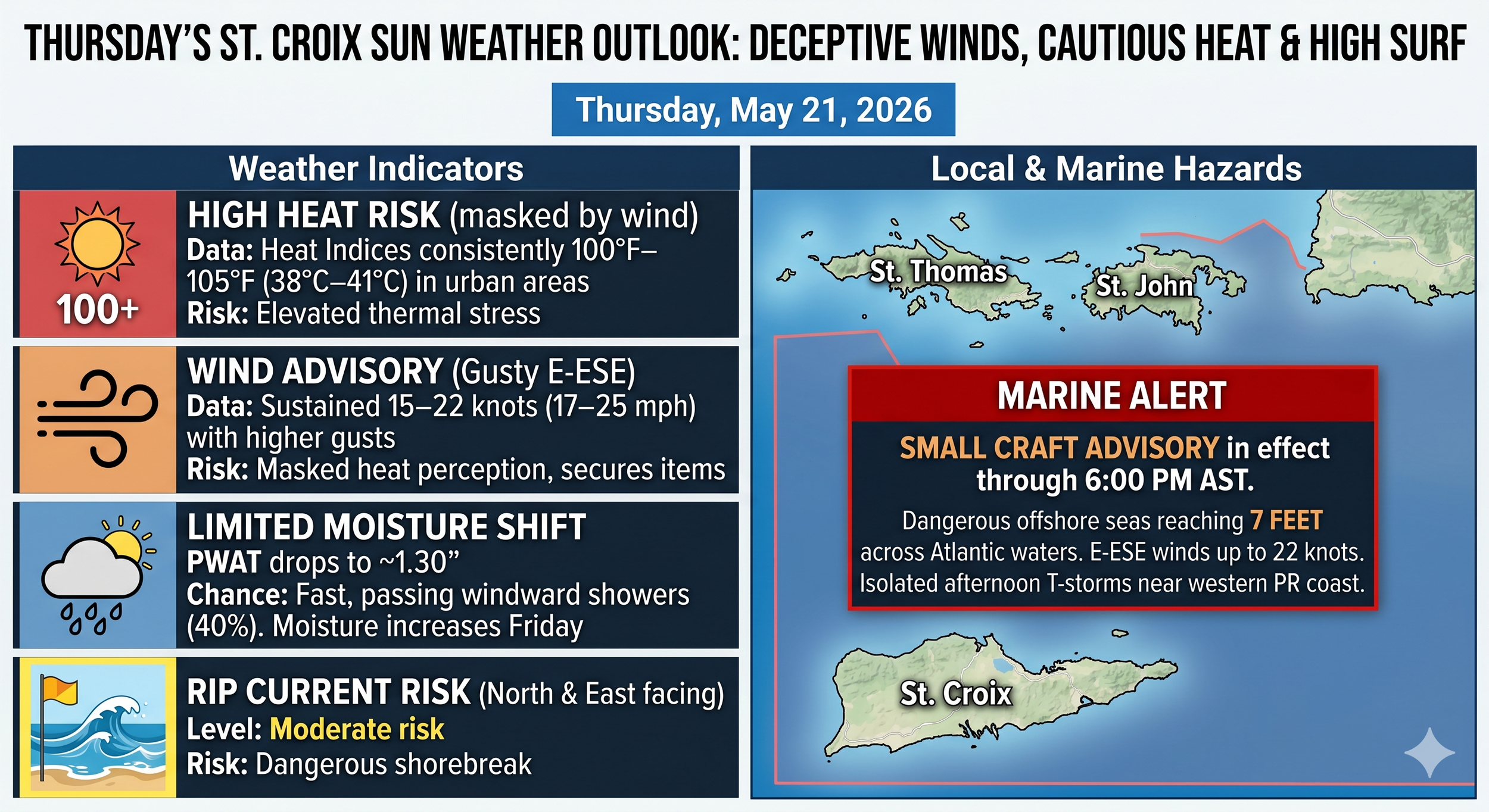
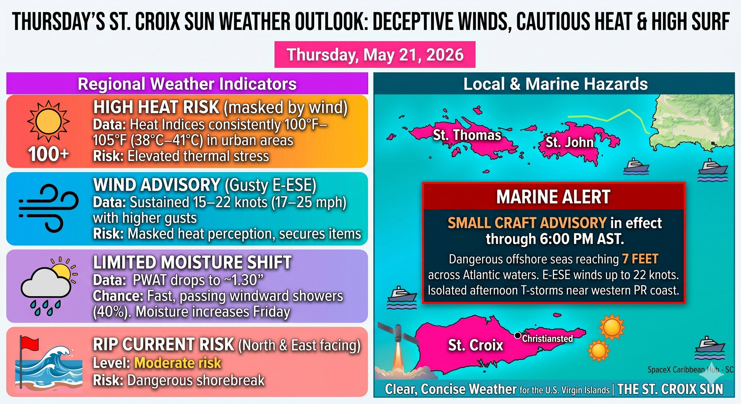
Weather Overview for Today, Thursday, May 21, 2026
Temperature & Heat Index: Ambient high near 31°C (88°F), with the heat index peaking between 38°C and 41°C (100°F–105°F).
Winds: East-southeasterly at 15 to 22 knots (17 to 25 mph), with higher occasional gusts.
Marine & Beach Hazards: A Small Craft Advisory remains in effect until 6:00 PM AST for the offshore Atlantic waters due to seas reaching up to 7 feet. A moderate rip current risk affects north and east-facing shorelines.
Precipitation: A temporary drop in atmospheric moisture keeps the rain chance at a modest 40% today, limited to rapid, passing trade wind showers. Moisture content will pool back into the area starting Friday, increasing shower frequency for the weekend.
Headline Advisories & Hazards
Small Craft Advisory: In effect until 6:00 PM AST this evening for the offshore Atlantic waters (AMZ711). Seas are reaching up to 7 feet across the offshore Atlantic due to persistent wind-driven waves.
Rip Current Risk: A moderate risk remains active across most local beaches, particularly north and east-facing shorelines of the USVI.
Wind Warning: Gusty winds may blow around unsecured outdoor items.
Marine & Beach Outlook
The surface high pressure system over the central Atlantic is strengthening and tightening the local pressure gradient. This setup ensures that choppy to rough marine conditions will persist.
Seas: Offshore Atlantic waters will see waves up to 7 feet today, subsiding slightly by this evening. Local coastal waters will remain choppy.
Winds: East-southeasterly winds are sustained at 15 to 22 knots (approx. 17 to 25 mph) with higher occasional gusts, peaking during the day before slightly decreasing after 11:00 PM AST.
Temperature & Heat Risk
This is perhaps the most critical daily impact for anyone spending extended time outdoors over the next few days:
Ambient Highs: Coastal areas will reach the upper 80s to low 90s°F.
Heat Index: Due to high seasonal humidity, the real-feel heat indices are projected to climb between 100°F and 105°F.
Precaution: The NWS explicitly warns heat-sensitive individuals and outdoor workers to secure adequate cooling, seek shade, and stay heavily hydrated during peak afternoon heating.
Precipitation & Moisture Trends
Today (Thursday): Precipitable water (PWAT) values are dropping slightly below normal this morning to around 1.30 inches. This drying trend means passing trade wind showers will move very quickly across the USVI with minimal local impact.
The Weekend Outlook (Friday–Saturday): Moisture begins pooling back into the region tomorrow, bringing PWAT levels back up to seasonal averages (1.5 to 2.0 inches). This will increase the frequency of fast-moving windward showers, though the high wind speeds will prevent prolonged standing water or significant flooding risks on St. Croix.
Technical TAF Aviation Note (St. Croix / St. Thomas)
VFR Conditions: Maintained across all terminals.
Wind/Shower Windows: Expect breezy E to ESE winds up to 22 knots with sea breeze variations after 9:00 AM AST. Brief periods of light showers (-SHRA/VCSH) are expected around the windward runways through 11:00 PM AST, though visibility will remain clear.
It looks like a solid, blustery day to keep the windows open, but definitely a day to be cautious if you are planning on heading out past the reef or working under the direct afternoon sun.